September 26, 2018

Under the Northern Lights

by backpackingbongos

The previous week had been frustrating. I was 430 kilometres north of the Arctic Circle and the Aurora forecast had been good. Whilst deep in the wilderness of Varangerhalvøya National Park and miles from any light pollution, cloud had stubbornly blanketed the night sky. I went to bed most nights with the sound of rain on my tent rather than gazing with wonder at the sky.

The Aurora forecast continued to be good whilst I took a backpacking break in a cottage 50 metres from the shores of the Arctic ocean. As the sun set the sky began to clear to the east, and as the first stars started to appear I went into the garden and looked up. The sky was not yet fully dark but I noticed a faint shimmer which intensified and then vanished before reappearing. East is not the best direction to look but the northern skyline was enveloped in cloud. To see the lights dance across the calm sea with Russia in the distance was magical. Sadly the cloud quickly filled the sky once more and I went back inside feeling disappointed at such a brief glimpse.

Later that evening I wrapped up warm and headed out onto the Arctic tundra behind the cottage in an effort to escape the light pollution from the surrounding street lights. The lights from the small hamlet were soon behind me but I was aware of the glow from the town of Vadsø to the south.

As my eyes adjusted I could make out a band of clear sky above the northern horizon. Initially it looked like a series of laser beams were being projected up into the clouds. These broke up and a band of light shifted across the horizon, the colour of the Aurora battling with the orange of light pollution from the nearby town. The evening flight to Vadsø came into land at the nearby airport, they must have had one amazing show above the clouds.

The Aurora was not constant in the sky, it would briefly intensify before fading to nothing. Twice I started to walk back to the cottage but would be stopped in my tracks as the search lights from below the horizon built up and released a curtain of light. It was evident that the lights were dazzling right about my head as the clouds filled with colour. It’s just a shame that the weather prevented them shining to their true potential.

April 2, 2018

The Arctic Trail – Kautokeino to Kilpisjärvi pt4 (mountains and waterfalls)

by backpackingbongos

The Arctic trail starts at Kautokeino in the far north of Norway and heads south for approximately 800 kilometres. It crosses into Finland and Sweden, finishing either in Kvikkjokk (Sweden) or Sulitjelma (Norway). To confuse things the trail has a different name in each of the countries through which it passes. In Norway it is called the Nordkalottruta, in Finland the Kalottireitti, and in Sweden the Nordkalottleden. In English it is simply called the Arctic Trail as the entire 800 kilometres are above of the Arctic Circle. Not to be confused with the Arctic Circle Trail, which is in Greenland!

Part one can be read here.

Part two can be read here.

Part three can be read here.

It was a blessed relief at dawn to escape the claustrophobic confines of the hut. It had been a painful and uncomfortable night, the room hot and stuffy. The rain of the previous day had blown through and it was good to watch the hut recede into the distance.

The Norwegian / Finnish border was a relaxed affair, a large cairn painted yellow and adorned with a reindeer antler. I had no goods to declare so was able to cross unhindered.

A couple of kilometres past the border and the trail passes the wilderness hut at Kopmajoki. In Finland they have a network of wilderness huts which are free to use, more information can be found here.

The hut was extremely homely and I immediately started wishing that I had stayed there the previous night. It had bunks for six people, a gas stove and utensils for cooking, plus a wood burning stove. Outside was a wood store that was filled to the brim with chopped birch wood, and an enclosed privy nearby. The log book indicated that no one had stayed the previous night. The hut itself was absolutely spotless with not a scrap of litter or even any dust on the floor.

I was soon joined by Thomas with whom I had shared the hut the previous night. As the trail that day would go over a 930 metres pass we decided that we would team up to cross it.

The main difference between hiking the Arctic Trail in Norway and Finland are the trail markers. In Norway I was always on the lookout for a painted red T either on rocks or a cairn. In Finland the trail is marked by a short wooden post about thirty centimetres high with a yellow top. I found the Finnish version less visually obtrusive, which really translates as harder to spot!

As we started the long climb up the pass our conversation turned to pack weight, as Thomas was clearly struggling with his. It turned out that he had started his trek with it weighing about 40kg, a weight that I would struggle to lift let alone carry across rough terrain. Much of that weight appeared to be camera gear, including several lenses. My pack at the start had been around 20kg, probably at my limit these days and relatively light considering I had supplies for twelve days.

The trail crossed the wide Goapmajohka and I did a really stupid thing. I focused on keeping my feet dry instead of just wading across. Whilst boulder hopping I lost my footing and fell forwards, straight into the river. Thankfully I went down onto my knees so I remained dry above the waist, however I was soaked from my undies downwards. Thomas was ahead so I avoided the humiliation of my lack of grace being witnessed. I removed my waterproof trousers in the hope that I would slowly drip-dry, even though there was a fine drizzle.

The path was soon lost in a tangle of boulders and the mist came down as we approached the top of the pass. One of us would stand still whilst the other looked for the next marker, this was repeated for what felt like hours. If we weren’t crossing slippery boulders we were standing ankle-deep in water. It was a relief to cross the highest point and squelch down to the next wilderness hut located next to the large lake called Pihtsusjarvi.

The verandah was full of huge rucksacks but there was no one in the hut itself. I peeled off my sopping wet boots and socks and set about making a hot drink and cooked noodles for lunch. It was good to air my feet, even though I knew I would have to put the same soaking items back on again.

As we were about to set off, the owners of some of the rucksacks appeared. They had been up to the summit of Halti, the highest point in Finland, a goal for many Finnish people. The highest point in Finland is at 1,324 metres whilst the actual summit is a kilometre to the north in Norway at 1,365 metres. There had been talk a couple of years ago about Norway gifting the summit to Finland, however it never came to pass. Due to the popularity of the hike the previously empty trail soon became much busier on the way to Kilpisjärvi.

A river flows wide and strong from the lake, becoming an impressive waterfall at Pihtsusköngäs. The power and noise was incredible and we stood mesmerised at the top for a while, becoming soaked by the spray. It’s worth taking a small detour from the main path to get a proper look.

The cloud was slowly lifting again, giving us a good view of the surrounding mountains. This part of Finland is surprisingly rugged.

With much more foot traffic on the trail it became easier to follow, although still exceptionally rough and bouldery. The cumulative effect on my boots was that they looked like the top layer of leather had been sandpapered away.

As the afternoon wore on finding a decent pitch began to look increasingly unlikely. The ground was either solid rock or prickly tent killing vegetation. In the end we found a spot above the river and got the tents up whilst it was still dry. I wandered around for a while waiting for it to air as it was still soaked from being flooded out a couple of days before. It really was a cracking location, especially with the autumn colours which had burst into life.

It rained all night, leaving a residue of low cloud and drizzle the following morning. There was a softness to the light that somehow accentuated the colours of the vegetation and the lichen on the rocks. Everything was slick under foot and we had to shuffle across areas of board walks over marshy areas and impenetrable boulder fields.

The verandah of the locked wilderness hut at Meekonjarvi provided some shelter from the weather whilst we snacked. We could not be bothered with the half mile detour to the open hut. Often the Finnish wilderness huts have an open section and a locked reservable section. In busy areas if you want to be sure of a bed you can reserve in advance for a small fee and pick up the key. Apart from that the facilities look to be the same.

Once again we climbed towards another high pass, this time through a wide valley. To start with there were excellent views but we soon found ourselves swallowed by the mist.

The wilderness hut at Kuonjarjoki loomed out of the clouds just in time for lunch. A pleasant half hour was spent there in the company of some young Finnish men, who patiently answered all my questions about their country. How they managed to remain so clean and well presented after a few days in the mountains amazed me. I was filthy by this stage and was very aware of my unwashed clothes and body in the warmth of the hut.

Thomas decided that he had had enough for the day and wanted to stay in the hut. I was keen to press on so that I could reach the luxury of my booked accommodation as early as possible the following afternoon.

Sadly there were no views from the 950 metre high pass, just more boulders looming out of the mist. It was whilst descending that my mobile suddenly pinged into life, informing me that I had unknowingly been involved in a spot of drama the previous couple of days.

Apparently the two messages I had sent from the hut after injuring my arm had not gone through. My wife, and friends Chrissie and Geoff had been tracking me on Social Hiking via my Spot3 device. When I had reached that hut in Norway at 10.30am I sent two messages and then did not move until early the next day. Because those messages were never received all they knew was that I had stopped moving for some unknown reason. By early evening they started to properly worry and decided to call the Police. Interpol and the Norwegian Police were informed after my wife had lots of fun and games being passed on the phone between various people who were unsure what to do. She informed the Police the following day that I had started moving again, but it appears that no action had been taken anyway!

The moral of the story is that you really should not rely on tracker devices to keep you safe. They are simply an additional tool. Funnily enough the time when I was being reported as missing was when I was in pure agony with my arm. I really would have welcomed a rescue at that point!

I pitched that night just off the trail on the shores of a high lake. The temperature really dropped and there was a damp chill in the air. Mist covered the surrounding hills, sometimes drifting just a few metres above the water. It was an atmospheric place to spend the last night on the trail. A few people passed me during the evening heading for the wilderness hut at Saarijärvi.

The trail the following day continued to be tricky underfoot, constant boulders meant that it was hard to really stride out. As I once again crossed the border into Norway and then back into Finland I could almost smell civilisation. I passed a few day hikers, the first I had seen on the entire trip, their scent of soap and detergent strong after so many days in the wilds.

As the trail descended I was once again in the birch forests which were ablaze with colour. Part of me really wanted to spend time and savour the last few kilometres, whilst the other part was keen for a shower, fresh food and a comfy bed.

I had splashed out in advance and booked an apartment in kilpisjärvi for a couple of nights. I apologised for my smell when I entered the homely reception area. The owner said that it was normal for people in the area to smell like ‘nature’. I was soon sat on the balcony with a pizza and cold beer, both pleased and relieved to have completed one of my toughest treks yet. In a couple of years I plan to return and continue on down the Arctic Trail.

The paper map that I used on this segment is the 1:50,000 Halti / Kilpisjärvi by Karttakeskus. It’s an excellent map and nearly as good as Ordnance Survey in detail. A step up from the Norwegian maps used on previous segments.

Whilst hiking I shared my route live on Social Hiking. That route can be found here and viewable on Google maps.

December 10, 2017

The Arctic Trail – Kautokeino to Kilpisjärvi pt3 (mist and misery)

by backpackingbongos

The Arctic trail starts at Kautokeino in the far north of Norway and heads south for approximately 800 kilometres. It crosses into Finland and Sweden, finishing either in Kvikkjokk (Sweden) or Sulitjelma (Norway). To confuse things the trail has a different name in each of the countries through which it passes. In Norway it is called the Nordkalottruta, in Finland the Kalottireitti, and in Sweden the Nordkalottleden. In English it is simply called the Arctic Trail as the entire 800 kilometres are above of the Arctic Circle. Not to be confused with the Arctic Circle Trail, which is in Greenland!

Part one can be read here.

Part two can be read here.

Pitched above 650 metres I was exposed to the wind that increased during the night. The rain was intermittent to start with but by morning it had gained some urgency, flying horizontally across the open hillside. As I was packing I heard a shout and stuck my head out of the tent and was greeted by five waterproof clad guys, rucksack covers flapping over huge packs. A quick conversation established that they were heading to Kilpisjärvi, my final destination. They were in high spirits and I watched as they climbed the hill beyond my tent and disappeared into the mist.

After enjoying mornings of being able to pack outside the tent under blue skies and sunshine, it was no fun doing so in the confines of the Enan. A mass of wet flapping nylon was then wrestled into its stuffsack and off I set into the wind and rain.

This was the day where I was hoping for good clear weather as the trail contours high along the hillside, staying above 800 metres for a few miles. I could sense the space to my right, the map indicating a huge drop to the valley hidden in the mist. With the wind blowing the rain directly into my face it was a matter of putting my head down and getting on with it.

In some ways I was enjoying the grimness of it all, after days of freakishly perfect weather it was good to have a bit of variety. I marched along with the aim of getting to a warm dry hut by the end of the day.

Sometimes it’s easy to get lulled into a false sense of security and forget just how remote the area is that you’re in. Accidents can happen so quickly and when they do you realise just how vulnerable you can be as a solo hiker. Easy angled slabs surrounded what looked to be a pretty innocuous stream. I literally put one foot down and instantly I fell heavily on my side, my arm pinned underneath me. I don’t know what hit first, the pain or the shock. I lay on the wet rock for a while, unable to move due to my heavy pack. I had dropped my hiking pole in the stream and watched as it started a slow descent towards the sea. Luckily I managed to stop it with my foot by sliding further down the slab, and then escaped from my rucksack which was holding me down like an upended tortoise. I sat there for ages, horrible pain in my upper arm whilst I continued to be battered by the wind and rain. It’s the loneliest that I have ever felt in the hills.

It took a while before I dared move my arm, thankfully everything moved ok and any prodding did not hurt too much. All the pain was deep inside my upper arm. I pondered what to do. It was a good long days walk back to the end of the dirt road at Saraelv. I would then have to either walk another day to the village of Sappen or try to hitch (being Norway Taxi’s are way out of my budget!). Even then I was unsure where to go for medical help or how to eventually get to Tromsø for my booked flight home. The alternative was to continue for the final eighty kilometres to Kilpisjärvi in Finland and the comfort of an apartment I had booked for a couple of nights. I would then be in easy reach of Tromsø and medical facilities if needed.

Seeing that I could actually move my arm I decided to continue as planned. It was difficult putting my rucksack back on and I could not use a trekking pole in my left hand. I continued on into the mist, wind and rain a lot less happy than I had been earlier that morning.

The problem with contouring slopes, especially in poor visibility is the fact that it feels like you are constantly walking up hill. It was with some relief to finally reach the high valley of Čoalbmevággi and its string of lakes. A sign pointed the way to the hut at Somashytta, 8 kilometres away. I knew that I would not make it that evening.

The wind whipping down the 750 metre high valley was ferocious, and when I found a spot that was relatively sheltered I decided to call it a day and pitch. Once changed into dry clothes and warm and snug in the tent I lay there and reflected on the day. My arm was throbbing and kept me awake as it was difficult to get comfortable. I lay there listening to the wind and unrelenting rain.

Something did not feel right at dawn. I sat up to find that the foot end of the tent was submerged in water, a small stream running through the porch. The bottom half of my sleeping bag and Thermarest were soaked, whilst my pack was positively floating. I immediately packed everything away, making sure that dry items remained dry and set off by 7am.

The wind had dropped slightly but the air remained as wet and misty as the day before. Water was running everywhere, the hills white streaks of water. As I crested a rise and looked down at what was meant to be a stream, my stomach knotted at what I was faced with. Flowing water filled a small valley, the faint trail entering the water and exiting it a couple hundred metres away. My boots were already saturated so I plunged straight in and slowly made my way across. Thankfully although the river was wide it only came to just above the knee and I made it to the other side without incident.

I was relieved to see the cabin eventually loom through the mist. There was a single occupant, a German chap called Thomas who had arrived the previous evening after a thirty kilometre battle through the weather. He had decided to take a rest day and although only 10am I decided that I also would not be continuing any further that day. Both myself and my kit was sodden and as I peeled off layers they were hung above the stove. The cabin was small with only two bunks sleeping four, plus space for a couple of people under the eaves. I bagged a bunk and soon had even more wet kit hanging from every available space. As I was finishing early for the day I placed my Spot3 device next to an open window in the sleeping area, firing off a couple of OK messages for my wife. The green flashing lights indicated that both went through ok, but more about that on the next and final trip report.

Not long after settling down with a hot drink and some food, three bedraggled Austrians appeared. It turned out that they were part of the group of five that had passed my tent the previous morning. Somehow they had got separated from the other two and had managed to follow the wrong trail. The two other Austrians had managed to find the hut the night before but they had the only map! The first thing they did once changed into dry clothes was give me a beer and then keep on topping up my coffee with strong rum. These guys definitely were not part of the lightweight brigade as they pulled bags of potatoes, tins and fresh steaks from their packs.

The last person to arrive later that afternoon was a serious young German lad who was thru-hiking the Nordkalottleden. He was doing it lightweight and definitely knew his technical fabrics.

As someone who prefers his own space, the tiny hut was almost a bit much for me with all the bodies inside. With the stove roaring and wet gear everywhere it soon resembled a very smelly sauna. I was also the only native English speaker among five German speakers, so some of the conversations were a bit lost on me!

As dusk started to fall and we were all beginning to get ready for an early night, vehicle lights were spotted approaching from further down the valley. Eventually three large quad bikes pulled up and the occupants entered the hut. It was clear that they had come to spend the night and were not happy that all the beds had been taken. We offered them the floor and then things started to get a bit heated. They were Sami men who were working with the reindeer in the mountains. Half of the hut is locked for which they have the key, whilst the other hut is for anyone to use. They said that they had forgotten their key and expected us to leave and pitch our tents (it was still very wet and windy and was now dark). Thankfully one of the Austrians spoke good Norwegian and managed to calm things down after lots of slamming of doors etc. They eventually ‘miraculously’ found the key to the locked side and with lots of swearing settled down for the night, after getting out chainsaws to noisily cut wood. The whole experience was rather unsettling as the Sami men were very big tough looking guys. To work outside in such a challenging area you would need to be pretty hard and hardy.

After all the excitement I found it difficult to sleep. My arm was still causing lots of pain which seemed amplified as I lay in bed, making it impossible to get comfortable in the tiny bunk.

It was with relief when someones alarm went off at 5am. I was keen to escape the cabin and head back into the lonely mountains.

The paper map that I used on this segment is the red covered Norge-serien 10154 Reisadalen.

Whilst hiking I shared my route live on Social Hiking. That route can be found here and viewable on Google maps.

If you’re interested in following this route on an electronic topo map they are in order below. You can click to view them full size.

October 10, 2017

The Arctic Trail – Kautokeino to Kilpisjärvi pt2 (gorges and waterfalls)

by backpackingbongos

The Arctic trail starts at Kautokeino in the far north of Norway and heads south for approximately 800 kilometres. It crosses into Finland and Sweden, finishing either in Kvikkjokk (Sweden) or Sulitjelma (Norway). To confuse things the trail has a different name in each of the countries through which it passes. In Norway it is called the Nordkalottruta, in Finland the Kalottireitti, and in Sweden the Nordkalottleden. In English it is simply called the Arctic Trail as the entire 800 kilometres are above of the Arctic Circle. Not to be confused with the Arctic Circle Trail, which is in Greenland!

Part one can be read here.

It took ages for the sun to reach the frozen tent, birch trees casting shadows over my pitch. It had been cold enough over night to turn water bottles and boots to ice. I dragged everything into the sun to allow the condensation to dry whilst I ate breakfast. The frost had finished off the insects of the previous evening, so it was nice to sit outside unmolested.

The trail that day was much easier to follow, first through birch trees and then climbing across low fells. I couldn’t have asked for better weather, cool and breezy and the bluest of blue skies.

The surrounding hills rose to around 600 metres and the landscape for a while reminded me of parts of the Grampians in Scotland. Once above the trees the path became firmer and for the first time it was actually possible to see it snaking off into the distance.

Sitting against a boulder, boots off and enjoying the sun I spotted a lone figure far down the trail. Initially I thought that it was a reindeer until I realised it was a biped with a long wooden pole. It looked strange at first as I had not seen another person hiking in the five days since leaving civilisation. As a self-confessed misanthropic hill walker I was surprised to find myself looking forward to having a brief conversation. It turned out to be a German guy who had walked the entire Nordkalottleden trail from Sulitjelma. With a tiny canvas backpack, checked shirt, Lundhags boots and wooden staff he looked like he had stepped straight out of the eighteenth century. He had walked the Nordkalottleden before and I was glad when he confirmed that the worst bit of the trail was behind me.

I asked if the DNT hut at Nedrefosshytta was locked and he confirmed that it was, a shame as I didn’t have the DNT key. He said that another German guy was a couple of kilometres ahead of me and was heading to the hut. He recommended staying the night as it was very comfortable and even had a sauna! He also let me know that there was a free hut before the DNT one that was meant to be good.

The trail began to descend back into the birch forest, with tantalising glimpses of the Reisadalen gorge and the mountains on its western side.

The map indicated the small hut just off the trail and close to the Luvddijdjohka river. I walked to the spot where it should have been and found nothing, even using my GPS to confirm my position. I walked in ever-widening circles and was just about to give up when I spotted a small structure at the bottom of a steep loose bank. I left my pack and went down to investigate. My nose confirmed what I thought it would be, I had found the privy, now just to find the hut.

Close to the river the vegetation was thick and jungle like. I walked towards the river and spotted a chimney poking out of what looked like a dense patch of trees, shrubs and grass.

I was expecting it to perhaps be a disused and overgrown Sami hut but when I walked round to the front I had a very pleasant surprise. It was like I had died and gone to hut heaven!

A stack of seasoned wood was in the open porch along with a new and sharp axe. The door was unlocked and the interior was both rustic and pristine. I was worried that I had entered someones private cabin, but a log book confirmed that it was available to anyone that can find it.

I set about unpacking and then lighting the stove which had been set by the previous occupants. It was a great opportunity to wash in hot water and wash and dry my trail stained and stinking clothes. The tiny hut was soon an explosion of kit, a mini sauna of dripping laundry.

Later as the sun was setting I climbed back up the steep bank to watch its descent behind the mountains. I stood for a while marvelling at the beauty and silence, my breath rising in the quickly cooling air.

I spent a while splitting wood after dinner, making sure that I replaced what I had used. I had to let the stove go out after going to bed as it was too efficient for the small cabin. I’m sure that it would be hugely appreciated when the temperatures drop to minus thirty in winter.

The lively river outside provided a noisy symphony to fall asleep to and I felt a bit restless wondering if someone would join me for the night. I woke and went outside after midnight for the loo and was treated to a small display of the northern lights.

It was great to put on clean clothes and pack dry kit the following morning. I made sure that the cabin was as I found it and walked back to the trail.

As I descended towards the Reisadalen the scenery became more dramatic, the trail beginning its long descent to the floor of the gorge. In the space of a few kilometres I went from sparse open forest and heath to being hemmed in by rock walls and thick vegetation. All the time I could hear the main river getting louder and louder.

There was a section where the trail is forced up above the river to traverse a loose and crumbling cliff face. Thankfully there were sections of wire bolted into the cliffs to give a handrail of sorts. With a large pack I found the going a bit hairy in places and didn’t dare let go and risk a photo. The trail then traversed some large scree slopes with big drops to the river below. None of this was particularly difficult but I did realise that I was on my own and a very long way from civilisation.

I was glad to see the wooden suspension bridge that would allow me to cross from the east to west side of the valley.

It was surprisingly bouncy and felt a long way above a particularly deep and dark section of river. I kept my eyes straight ahead and did not look down!

The DNT hut of Nedrefosshytta was firmly locked so I sat in the porch and had a snack after peering through all of the windows. It did look particularly plush inside and at around £15 a night looked to be very good value. When I return to Norway I’ll make sure that I join the DNT and obtain a key.

Just as I was leaving I met a French guy walking in the opposite direction. He was completing the trail in one go and gave me a few tips for the route ahead. He was travelling with a small pack and trailshoes and was quick to point out the trouble he had with snow earlier on in his hike. He said that his trailshoes had made crossing deep and steep snow difficult.

The highlight of a visit to Reisadalen is the Mollisfossen waterfall. This has a total drop of  269 metres (883 feet) and plunges over the cliffs of the canyon. I heard it long before I could see it as initially it is hidden by cliffs.

Sadly it is located on the other side of the river which is far too deep and strong to even attempt to cross. I had to be content to view it from a distance. Even so it was pretty impressive.

I had read of the difficulty of walking through Reisadalen due to the vegetation and possibility of the river flooding the path. I can imagine that this vegetation obscures the path early in the summer and it would be a tough bush whack to get through. However by September lots of feet had bashed a path through the tall ferns and it was mostly easy to follow. Thankfully it was dry as you would otherwise get absolutely soaked!

Easy walking was punctuated with sections of boulders that require careful footwork. These were slow and tiring and as the day progressed I was always on the look out for somewhere to sit.

Being a Friday there were a few boats going up and down the river, shuttling hikers (and dogs) up to Nedrefosshytta. An excellent way to travel deep into the National Park. With the river being low it looked like the boatmen were having difficulty in picking a route. They were travelling in long motorised canoes with plastic garden chairs for the passengers.

I had planned to stop and pitch at Sieimma with its locked hut, fireplaces and picnic area. However the area was a mess and full of rubbish so I decided to push on. Being Friday evening there was also the risk of folks coming later by boat.

I did wonder if I would regret carrying on as the path turned rocky again. After spotting a tent sized patch of flattened vegetation I did not hesitate to pitch. It was a beautiful spot underneath a big old pine tree, cliffs to the rear and the river in front.

A couple of boats passed after dark and later on there were a couple of what sounded like gun shots echoing down the valley. Apart from that it was a comfortable night, insect free and with the door of the tent left open.

Being close to a river and surrounded by vegetation I was expecting everything to be soaked by condensation in the morning. Strangely it was the driest morning of the whole trip, even the flysheet was bone dry. I got up knowing that the weather was forecast to break later that evening. The plan was to get as far as possible to shorten a high and exposed section the following day. I cooked and ate breakfast outside, not knowing that it would be the last time I would be able to do so on this trip. The weather was soon going to be a major factor, both in terms of safety and enjoyment.

I walked the final 10 kilometres to the dirt road at Saraelv, which my map marked as a settlement. My hope would be that there was a small cafe or somewhere to buy a coffee and some snacks. There was nothing! I had enough food but my appetite had increased and I wanted a little extra to satisfy the permanent hunger. It’s not easy carrying 12 days food and ensuring a full belly.

The trail follows the dirt road for a short distance before a sign points the way back into the mountains. Having dropped down to only 100 metres above sea level I knew that it would be an upwards slog. I stopped for a while at a very impressive waterfall and nervously crept to the edge of a terrifying drop to the river far below.

As I climbed higher pine made way for birch once more, yellow in their autumn glory. The landscape that I was in reminded me of the Scottish Highlands, but with the addition of trees on the lower slopes. With both countries having a similar climate (with Norway being even harsher) there is definite scope for re-wilding in Scotland. Instead we seem hell bent on destroying that landscape, the feeling of wildness disappearing at an alarming rate.

Above 500 metres the last of the trees were left behind and I plodded upwards under an increasingly leaden sky. Finding a place to pitch became increasingly difficult, the vegetation short but spiky.  A patch of relatively flat bilberry between two streams was adequate in the end, rocks being used to secure guy lines in the strengthening wind. I got my gear in the tent and went to fetch water just as the first spots of rain began to fall. The good weather on this trip was now behind me.

The paper maps that I used on this segment are the red covered Norge-serien 10165 Guovdageaidnu and 10154 Reisadalen.

Whilst hiking I shared my route live on Social Hiking. That route can be found here and viewable on Google maps.

If you’re interested in following this route on an electronic topo map they are in order below. You can click to view them full size.


September 24, 2017

The Arctic Trail – Kautokeino to Kilpisjärvi pt1 (marsh and forest)

by backpackingbongos

The Arctic trail starts at Kautokeino in the far north of Norway and heads south for approximately 800 kilometres. It crosses into Finland and Sweden, finishing either in Kvikkjokk (Sweden) or Sulitjelma (Norway). To confuse things the trail has a different name in each of the countries through which it passes. In Norway it is called the Nordkalottruta, in Finland the Kalottireitti, and in Sweden the Nordkalottleden. In English it is simply called the Arctic Trail as the entire 800 kilometres are above of the Arctic Circle. Not to be confused with the Arctic Circle Trail, which is in Greenland!

When researching this trail I found that there was little written in English. Hopefully this blog will be helpful for others planning a similar trip.

The plane was half empty when it landed in Alta at 11.00pm on a Friday night, most passengers had disembarked during the brief stopover in Tromsø. Alta is the second most northerly city in the world with more than 10,000 inhabitants. Waiting for my luggage in the tiny airport I watched the passengers wrap up warm and disappear into the dark and rainy night.

The last bus into town had long gone so I walked over to the empty taxi rank, wondering what to do. Thankfully a taxi pulled up within a few minutes. I passed the handwritten address to the driver for the Airbnb that I had booked, then marvelled at the speed at which the meter racked up the fare as we headed towards town.

There is something rather disorientating about arriving in a strange place late at night. Thankfully my host who was away for the weekend had sent me a video showing how to find and get into the apartment. Otherwise I fear I would have spent the night under a tree in the rain.

I was eager to check out my surroundings the following morning and have to say that I was blown away by the ‘city’ view from the decking outside.

I had planned a town day to get some final supplies including gas, and to double-check that a bus would get me to Kautokeino the following afternoon. Research at home showed that there was no direct service on a Sunday (and none on a Saturday) and that the connection that I needed was exactly zero minutes long. Emails to the bus company had been ignored, so I set off on the walk into town rather anxious and keen to get some definite information.

That anxiety was heightened further when I discovered the bus station was simply a weedy patch of gravel and the tourist information centre was closed for the weekend. There was an electronic board in the window showing the first bus I wanted, but no indication of the connecting service. It would be a case of turn up and see the following afternoon.

With gas and food for my stay in Alta procured I headed back to the apartment and made up some lunch for a short hike. My accommodation was located on the lower slopes of the 213 metre high Peak of Komsa. A myriad of paths lead to the rocky summit and a view that is out of proportion to its small stature.

The next day I had a long time kicking my heels, with check out from the apartment at midday and the bus at 16.05. Alta is not a Sunday town and the main street was pretty apocalyptic in its complete absence of life. Most of Alta’s shops are in a single shopping centre which was closed. I suppose that when you are 236 miles north of the Arctic circle and the sun does not rise for two continuous months, indoors is attractive!

I managed to waste a few hours by loitering on a bench and then going for a very expensive pizza,my bus anxiety growing.

When the bus arrived I was pleased that I managed to pronounce Kautokeino correctly and relieved that the bus driver would be driving the connecting bus. The journey went smoothly and when we arrived at Gievdneguoika (just a bridge) there was already a bus waiting on a lonely road in the absolute middle of nowhere. Passengers and luggage were swapped over and I finally relaxed on the final half hour into Kautokeino.

Before setting off to find the start of the trail I popped into the garage / service station in town for a snickers and a can of coke. It set me back just over £6. I was glad that my wallet was going to stay in my rucksack for the next twelve days. That rucksack was heavy, weighing just over 20kg. It contained everything that I would need for 12 days whilst crossing a large chunk of wild and remote terrain.

The actual trail starts a couple of kilometres out of town at a hand painted sign and a deteriorating information board. The information board appeared to suggest that I initially take a parallel route to the official one I had marked on my map. In retrospect I think that perhaps it meant don’t take the parallel route. I should have brushed up on my Norwegian.

Anyway the parallel route started off as a nice soft track through the birch trees. I realised that I was not going to get as far as I initially planned that first day. I had got the sunset times wrong and it was going to be dark earlier than I thought. The light was already fading under the leaden sky.

The trail passed between two lakes so I filled my water bottles, hood up to avoid the mosquitos that were keen on a meal. I then headed back along the trail a short distance to a flat patch of mossy ground that I had spotted. Suitable pitches can be difficult to find north of the Arctic Circle. The ground is either rock, bog or tough prickly vegetation. You have to forget about the lush grassy pitches of the UK.

It’s only when my tent is first pitched and my gear laid out that I start to relax on a long backpacking trip. When I realise that I have not forgotten anything and the stress of getting to the start of the trail is over.

Although in early September the nights are quickly drawing in, dawn still comes early in the Arctic. I woke to clear blue skies and a chill in the air. I sat and ate breakfast outside the tent, waiting for the condensation to dry before packing it away.

The track continued to give easy walking and the sound of traffic on the road into Kautokeino began to fade. At regular intervals I checked my position on both the map and on my GPS, pleased that this ‘alternative’ route was so straightforward. I began to hope that the whole route would be a nice stroll in the park.

The track slowly started to fade and I realised that it had not connected with the official route as it should have done. Using my GPS I set off into a tangle of birch and undergrowth on a mission to get back on track. I found exactly where the trail should have been but there was no sign of it on the ground. I navigated through dense vegetation on the line of the trail, cursing and wondering where it had gone. This continued for some time as I came to an open marshy section, the trail nowhere to be seen. I squelched my way across, occasionally backtracking to avoid particularly deep or wobbly sections. Slow moving streams would be particularly boggy and difficult to approach.

I got to the other side of the shallow valley and was relieved to climb onto firmer, drier ground. Although this meant getting tangled in vegetation once again. With a heavy pack, surprisingly warm weather and biting insects I was already wondering if I’d bit off more than I could chew.

And then suddenly I came across the narrowest of paths, red blazes of paint on the trees. An intermittent trail to follow increased my confidence and quickened my pace. The rest of the day was spent frequently losing this trail as it wound its way through bog, marsh and forest. The worst section was a combination of marsh and forest, the trail being a knee deep ordeal of stinking black bog. One small stream was just a little too wide to jump across. It looked to be only a few inches deep so I walked across, sinking to my thighs in the swamp hidden beneath. I walked in wet undies for the rest of the day.

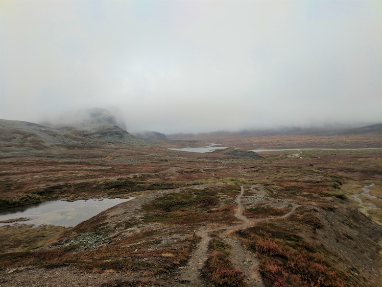
The trail once again became a firm track as higher ground was reached and it wound its way towards the 528 metre summit of Goaskinvarri.

This small summit was the first time that I was able to appreciate the sheer scale of the landscape that I was in. In some ways the view was more impressive than an array of jagged peaks. There was literally nothing as far as the eye could see, just a vista of forest, lakes and low fell. I imagined what it would be like during a mid winter storm in such an open and exposed place.

After another section of wet ground I decided to pitch early after spotting another soft and flat area of deep moss and lichen. It was beautiful being at the edge of the forest, the trees a golden yellow, open fells rising above a brightly coloured marsh. The insects were out but not too troublesome and they all dissapeared during the cool Arctic evening.

I woke just after midnight and popped my head out of the tent to see my first ever show of the Northern lights. A wisp of green was pulsating overhead, coming and going like it was blowing in the wind. I wish that I had got up and set up the camera. Instead I took some snaps on my mobile and was soon asleep again. The trail had taken its toll.

The following morning I got creative with the route. The Arctic Trail (Nordkalottruta) heads towards the road and then does a loop around the hamlet of Čunovuohppi and a hut with the fabulous name of Madam Bongos. I however had noticed an unmarked trail on the map that instead would take me over some low fells and rejoin the route. I was keen to get up high again rather than flounder through boggy forest.

It turned out to be a good decision as a clear path led across a crisp landscape with fantastic views under the clearest blue skies imaginable.

As I rejoined the trail (after spending an hour looking for it) I noticed what I had found strange over the past couple of days. The skies were completely empty, there were no planes or helicopters. Just the sound of the wind and my own footsteps.

Later that day I found out that although devoid of hikers this area is the work place of the Sami people. I met four in total on huge quad bikes out checking their reindeer and the reindeer fences. They were all friendly, stopping to see what I was up to and where I was heading. One explained that one side of the fence was the winter grazing ground whilst the other was for summer. The reindeer would soon be swapping sides.

The rest of the day was thankfully spent above the tree line, which this far north is 450 metres. A series of quad bike tracks led easily across the hills and I passed an eerily quiet Sami settlement, a collection of small cabins and the ubiquitous rotting caravan.

I pitched a bit higher that night, just above 500 metres. The wind was cold and strong and the tent pegs struggled to get a good purchase in the thin soil. Several large rocks had to be deployed to keep the tent attached to the ground. It was a great evening sitting snug in my tiny tent listening to the wind and watching the moon rise.

The trail early the next day stayed high, leading to the 600 metre summit of Rivkkos. The first thing that drew my eye was the large Ráisjávri lake just within Reisa National Park. The Arctic trail (Nordkalottruta) would follow the shoreline before heading towards the gorge for which it is known. On the horizon I could see the snow capped peaks of Halti which I would cross the following week.

The one manmade intrusion into this part of the trail is a powerline that cuts through the wilds in an unnaturally straight line. Thankfully it is a double wooden pole version rather than the steel monstrosities of home. Most of the time you can’t really see it but there are sections when the trail crosses it.

Along the eastern shore of Ráisjávri it provides a good handrail, although this did not stop me losing the path yet again in a mire and tangle of undergrowth.

Losing the path meant that I did come across an atmospherically dilapidated hut in the forest. Complete with rotting furniture and curtains it was straight out of a horror movie.

There are a few cabins around Ráisjávri but no one was at home, the only sign of life being a smokehouse giving off a wonderful smokey / fishy aroma. I would have happily have purchased an arctic char to go with dinner that night.

Shortly after passing the locked cabin at Ráisjávrihytta I crossed the boggiest bog that I have ever experienced. It wasn’t just boggy but bordering on dangerous. The whole area had been churned up by quad bikes so was a quaking, black oozing mess. Matting has been laid on top on some sections but there is nothing to secure it to. I wouldn’t be surprised if people haven’t sunk there without trace. At least there was a deep, wide and freezing cold river to cross before getting mucky again.

After the bogs of doom the ground became drier and a series of quad bike tracks over stony ground were followed. The end of Ráisjávri was passed and the scenery began to open up, hills rising to the north.

There was one more river to cross that day, the ritual of taking off boots and socks and putting on a pair of sandals. The water cold enough to make you gasp. I was never hard enough to go for a proper dip.

I found a well used pitch close to the river, the surrounding trees even more yellow than ever. It was cold enough that night to freeze the platypus bottles solid along with anything else left in the open porch.

The paper map that I used on this segment is the red covered Norge-serien 10165 Guovdageaidnu.

Whilst hiking I shared my route live on Social Hiking. That route can be found here and viewable on Google maps.

If you’re interested in following this route on an electronic topo map they are in order below. You can click to view them full size.