Posts tagged ‘Scottish Highlands’

May 2, 2017

Ben Klibreck and a bothy night

by backpackingbongos

Over the years I have ended up planning to climb Ben Klibreck during the dark end of Autumn. This has never been a very good tactic, as I end up sitting in the van on the road below thinking ‘Perhaps not today’. This is usually due to a big cap of cloud cloaking its summit or a gale rocking the van.

The 27th November 2016 once again saw me sitting in the van on the road below the mountain. However for once the russet moorland grasses were lit by a low sun sitting in a wintry blue sky. After a long journey even Reuben was enthusiastic about leaving his warm comfortable seat and heading into the Highland chill.

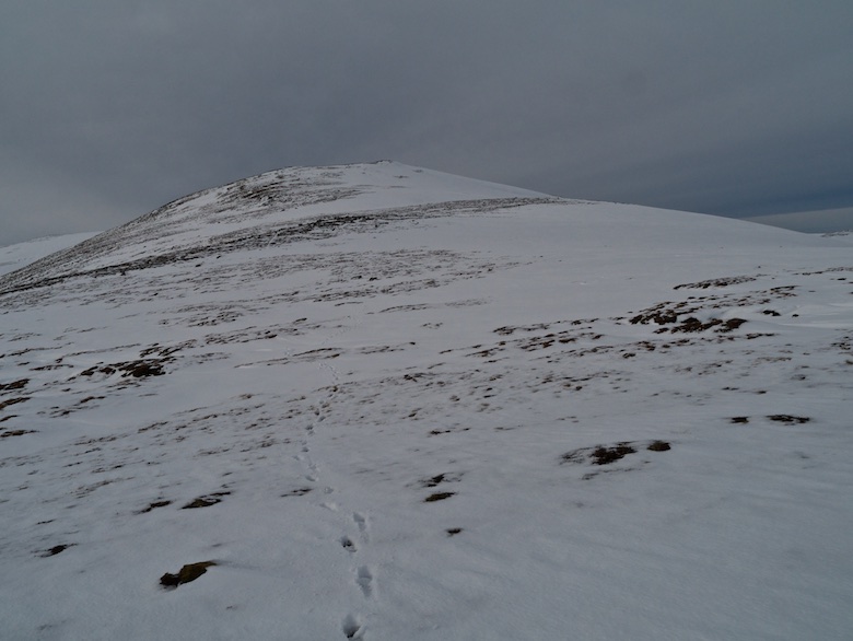
The day was short so I decided that the route would be by the standard Munro baggers path. This was boggy and slippery until firm ground was reached on Cnoc Sgriodain. As is usual in the Northern Highlands the higher ground often gives much easier conditions underfoot. The lower slopes are usually a tangle of heather or tussocks, peat sucking at your boots.

A fine path contours the slopes below Creag an Lochan and my eye was soon drawn to the wild and empty land to the west. It’s a huge vista with barely any influence of man visible. It truly is magnificent.

One of the reasons why I have been so eager to climb Ben Klibreck the last few years is because of the imminent Creag Riabhach Wind Farm. This will see twenty two wind turbines up to 125 metres (410 feet) high, on the ground in the middle distance. If it finally gets built it will decimate this stunning part of Scotland, unnecessary industrialisation of a very wild area.

By the time I had averted my gaze and gained the ridge proper the clouds were rolling in, seemingly appearing from nowhere. However I suspect that they had been hiding on the other side of the mountain all along.

It was cold on the summit and the clouds obscured the view, I was enclosed in a damp and windy world, visibility down to a few metres. I had been using the app Routebuddy on my phone as a convenient pocket sized map. Unfortunately the cold immediately killed the iPhone battery as I was taking some photos on it. Luckily I always carry a paper map as back up, but where was my compass? I then saw it in my mind, safely sitting in the pocket of my backpacking sack that I would be using later that evening. I had forgotten to swap it between sacks as the day before I had been backpacking. The perils of doing a trip that mixes both day walks and backpacking routes!

Thankfully the return simply involved retracing my steps, it would have involved a lot of effort to actually get lost. As I picked up the narrow path once again the mist started to thin. Silhouettes of nearby hills started to drift in and out of view, the hidden sun providing a backlight.

Suddenly the mist parted like a curtain and I was treated to a very special sunset.

It was an amazing way to end a day on a mountain, however it is a strange feeling to have night come so early. It was dark around 3.30pm when I finally got back to the van, the sun would not rise until nearly 9am the following morning. It was going to be a long period of darkness.

I drove a few miles north across empty moors, a lack of lighting from houses or buildings a bit disconcerting. The roads were empty, the verges quickly eaten up by the inky darkness. There was absolutely nothing out there.

I initially missed the rough layby and had to double back. With no moon it was absolutely pitch black outside, the sort of darkness where you can’t tell your arse from your elbow. I relied on technology to pinpoint my exact location. My backpack was already packed and ready to go, heavy with coal and kindling. A few steps away from the van and it was gone.

I have to say that I panicked when I got to where I thought the bridge was and saw that it was not there. Thankfully after walking up and down the banks of the river by headtorch I found what I was looking for. The walk along the north shore of Loch Loyal gave me a handrail for navigation. The only sound was the crunch of gravel under my boots, the only thing to see was the red light I had attached to Reuben’s collar.

I finally approached the building with apprehension, would there be smoke in the chimney and candle light in the window? All was dark, cold and silent when I arrived at the door. The metal latch seemed loud, all there was inside was the faint ghost of woodsmoke. The bothy was empty and currently mine alone.

I bagged a small snug room for myself and Reuben, there was still the possibility of other visitors so I did not want to spread out in the main room. Candles were lit and the fuel I had carried in was soon filling the lum with fire and smoke. Dinner was cooked and cans of beer opened, Reuben snoring on his mat. For me a perfect evening.

With no moon and zero light pollution I kept popping out to see if the Northern Lights would make an appearance. They did not but the sky was full of a billion stars.

Bed time was early, Reuben and I tucked away in the wood panelled snug, the door shut against anything that may go bump in the night, secured against the bothy ghosts.

Nothing did go bump in the night and many hours later I was outside before dawn having a look at the previously hidden surroundings. The bothy is located in a magical spot.

With no facilities at the bothy I did the ritual walk of shame with the spade far away from both the building and water source. I was soon packed up, ensuring all litter was packed out, the fireplace clean and the floor swept. I was once again crunching along the gravel beach of Loch loyal, the sun finally rising for another short day. Onwards to my next adventure in the far north.

Achnanclach bothy is maintained by the Mountain Bothies Association. Full details can be found here, including the bothy code. Basically don’t be a dick, respect the building and other users, carry out your rubbish and any you find, don’t shit near the building or water source, don’t visit in big groups, leave fuel for others. Pretty simple really.

July 19, 2015

Stronelairg – 5 snowy days in the Monadhliath pt2

by backpackingbongos

Part one of this trip report was published a few months ago, unfortunately other trips got in the way and I never got round to writing part two. So cast your minds back to Easter this year……….

You can read part one here.

The contrast with the murk the day before could not be greater. The mist, low cloud and poor visibility had been replaced by blue skies and crisp visibility. The air was still and despite snow still laying on the ground it felt warm.

The upper reaches of Glen Tarff really is a gem, a place where no one really bothers to venture. I picked up the old stalkers path and climbed my way back onto the Monadhliath plateau, enjoying the retrospective views down the glen to distant snow-capped mountains.

P1090123

P1090128

The plateau was reached just south of the dam for the newly built reservoir. The sense of space on that clear spring morning was exhilarating. Sometimes you don’t need high craggy mountains, the empty rolling moors often make me feel just as happy to be out.

P1090131

P1090134

I was heading for the summit of the Corbett Gairbeinn. Normally this would be a straightforward affair of walking across the moors and climbing onto its long summit ridge. However with deep and rapidly melting snow on the ground it was not quite that easy. The various watercourses were covered in unstable snow bridges, banks ready to collapse either side. I spent a while linking up patches of snow free ground, often making detours when the snow became too deep and soft.

P1090139

The going was easier on the higher and steeper slopes, the snow still having a bit of bite which meant that I could kick steps up. With a heavy winter pack, warm sun and no wind I quickly felt exhausted. The high snow-covered plateau however was spellbinding and I did not need much excuse to just stand and drink it all in. I was sad with the knowledge that soon the whole area will be covered in wide roads and wind turbines.

P1090141

P1090142

The ridge of Gairbeinn was snow free but the east side was heavily corniced. There had recently been an avalanche which is visible in the third photo below. Some of the blocks of snow were the size of a chest freezer, not something that you would want to get caught up in.

P1090145

P1090147

P1090148

I lingered at the summit for a long time, out of the wind the sun felt warm and the surroundings were majestic. Across the infant Spey the Creag Meagaidh hills towered high and snowy. Much of the high plateau of the Monadhliath was still draped in virgin white, so I decided against a planned long walk across the summit of the Corrieyairack to bag some more Corbetts. Even though it was only early afternoon and I had walked only a few kilometres I decided that I would look for a nearby high level pitch and just enjoy my surroundings.

P1090150

P1090152

I backtracked along the ridge and then descended to the east to a good spot on the 780 metre contour. I pitched the Trailstar and spent a lazy afternoon and evening reading, brewing and eating. Taking time to walk around various vantage points above camp. The air soon became cold and crisp, the hills glowing in the setting sun.

P1090156

P1090158

P1090160

P1090164

It was only a short walk back to the car the following morning so I decided on a small detour to climb Creag Mhor. It’s a small hill that does not feature on any lists but it was worth the effort for the views along the upper Spey and back to the plateau from which I had come.

P1090168

P1090169

The often grassy banks of the Allt Gilbe eased progress back to Garva bridge. I passed a family picnicking next to the bridge over the Allt Coire Lain Oig, the first people who I had seen in five days. I could not think of a finer place in which to spend a busy Easter weekend than the lonely underrated Monadhliath.

P1090171

July 16, 2015

TGO Challenge 2015 – Days 12 to 14

by backpackingbongos

Days 1 to 3 can be found here.

Days 4 to 6 can be found here.

Days 7 to 9 can be found here.

Days 10 & 11 can be found here.


Day 12 – 14 kilometres with 220 metres ascent

Day 12

(Click map to enlarge)

It was the coldest night of the Challenge. I woke at first light and tried to unzip the fly which was a solid sheet of ice. The rain the previous evening had frozen and I was treated to an icy shower as I brushed against the Scarp. I went back to sleep for a few hours until the sun had risen over the hills and warmth filled my tent.

The Water of Unich was followed downstream for a bit before I crossed it and picked up a track that led up and over Carn Lick (I couldn’t find a cairn to lick).

P1090406

P1090407

The Shank of Inchgrundle is a great name for a very scenic ridge walk down towards Loch lee. The views along the Loch and up the Water of Lee to Mount Keen were splendid. The following two days would be across farmed glen, intensively managed grouse moor and country lanes towards the coast. I took the opportunity to savour the hills whilst I could.

P1090410

P1090411

P1090416

The walk along the Loch is via a well used landrover track. I stopped often and sat on various rocks in the sun, avoiding leaving the hills behind.

P1090418

Just past the castle and at the beginning of the public road I spotted Louise approaching from Glen Mark. After a couple of days on my own it was great to receive a warm hug and see a smiling face and we talked of our adventures as we walked together to Tarfside. The hill path that skirts to the north of the Hill of Rowan is a much better alternative to walking the road, although I have never been tempted to climb the small hill with the big monument.

We both made a beeline straight for St Drostans Hostel, an oasis of Challenger hospitality along with food and drink. The big kitchen table was crowded with other Challengers and it was great to catch up with others after a crossing mostly undertaken in solitude. I was offered a bed for the night in the hostel and jumped at the chance of a room all to myself. Louise was offered a room with a young handsome Canadian chap as they were mistaken as a couple (I think Louise was flattered). She then managed to draw the attention of the obligatory weird and sexist Challenger………

I sorted out my room and then sat in the lounge for a while to drink beer and be sociable with various folk who I knew through blogs and Twitter, but had not met in real life. Chrissie was on a grand tour of Scotland and had come to Tarfside to meet me and sample the social side of the Challenge. I wandered with Robin down to her van which was parked up next to the village green where we passed another sociable couple of hours drinking coffee and eating cake. I had booked dinner at the hostel so walked back to fill myself with Carbs. A night in the Mason’s arms with plenty of beer saw me heading back to my bed in the dark a little ‘dehydrated’.


Day 13 – 22 kilometres with 520 metres ascent

Day 13

(Click map to enlarge)

A mixture of alcohol coursing through my veins, a hot room and numerous people who can’t close a door without slamming it meant that I slept badly. Coffee and an egg cob settled my grumbling stomach and I headed off to walk the road to the Retreat with Louise. A mile later and we were stopping for breakfast number two before continuing along the road to Edzell. We said our farewells after a few more miles as Louise crossed the river to walk along the south bank of the Esk. I continued a bit further before taking the track that heads up to the moorland summit of Craigancash.

On the horizon above I could make out Alan Sloman and Phil and I did my best to try to catch them up. The views to the west were lovely but the hills around me were covered in tracks leading in all directions, the heather scarred with a patchwork of Muirburn. This part of Scotland is an intensively farmed monoculture used for the raising and shooting of grouse.

P1090420

On the climb I was aware of a figure watching me, the strange thing being that it did not move at all. This became more unnerving as I got closer. A man in a blue boiler suit and red hat remained motionless in front of me, it was only at the last moment that I realised that it was a mannequin. It was pretty obvious but I really had not expected to see a shop dummy with a wooden pole shoved up its trouser leg on a Scottish hillside. The fact that its mouth was taped made it all the more creepy.

P1090424

P1090426

I found Alan and Phil just finishing their lunch as I stopped for mine, so I was left alone to watch them grope another dummy of non specific gender that was hanging out further up the track. The coastal plains were far below my feet, green and yellow fields stretching to the sea which still looked a long way away. It was good to see it glinting on the horizon though, I was nearly at journey’s end.

Passing the dummy I could not help noticing that it was not suitably dressed for the hills, remember folks cotton kills.

P1090427

Progress was halted by a tall deer fence which fortunately was not electrified. It was a bit of a precarious climb to get over it though. It would be pretty much impossible with a dog, so perhaps not the best area to return with Reuben.

I caught up with Alan and Phil in a brand new shooting hut complete with comfy chairs and a functioning gas cooker. I soon left them to it as I was keen to get into Fettercairn and the hotel that I had booked for the night. It was a long descent down Herd Hill and through the Wood of Mon Duff. The final walk along tarmac left me feeling foot sore.

The Ramsey Arms was a real gem, by far the best place I have stayed in in Scotland. Friendly staff, bags of character and comfy rooms. Chrissie had motored over in the afternoon and parked up the van in the village. I was too tired to be sociable so headed straight to my room for a well needed shower and to rinse my filthy socks. It was a sociable evening in the bar though with Chrissie, Alan, Phil and another couple of Challengers whose names I have already forgotten. As well as Guinness they served up huge portions of excellent food. I wholly recommend the Ramsey Arms for food and lodgings and a final nights treat on the TGO Challenge.


Day 14 – 23 kilometres with 180 metres ascent

Day 14

(Click map to enlarge)

The last day of walking was not one I had been particularly looking forward to. Twenty three kilometres along tarmac is not really my idea of fun. After a decent breakfast I went and said good morning to Chrissie and the brown Lab Tilly and arranged for the van to become a mobile tea van around lunch time.

I headed off under leaden skies, a light rain falling for the long trudge to the east coast. Initially there was a nice path through beech trees but this soon deserted me and it was tarmac all the way. The crossing of the A90, which is a dual carriageway was a bit hair raising and I was glad to get across in one piece. Chrissie met me just to the north of the Hill of Garvock where I fortified myself with coffee, sandwiches and cookies. The timing was perfect as the rain got heavier whilst I was in the van.

The walk from there into Inverbervie passed without too much excitement, the towering turbines of a wind farm being a bit overwhelming at one point. I could not believe just how noisy they were even from a mile away.

Inverbervie itself is a pleasant place to finish, a functional Scottish seaside town. I met Chrissie and Tilly for a celebratory dip of my toe in the sea. I had decided the day before that I could not face the Challenge meal in Montrose. I really did not fancy camping at the busy Montrose campsite (not particularly pleasant) and all accommodation in the town had been booked up. Instead I secured a cheap room at the Star Inn in Inverbervie which was actually very pleasant and excellent value for money. I met Chrissie that evening at the Bervie Chippy for a celebratory meal. A pleasantly understated way to finish my third TGO Challenge.

P1090430

July 9, 2015

TGO Challenge 2015 – Days 10 and 11

by backpackingbongos

Days 1 to 3 can be found here.

Days 4 to 6 can be found here.

Days 7 to 9 can be found here.


Day 10 – 22.5 kilometres with 880 metres ascent

Day 10

(Click map to enlarge)

Harmonicas should be banned from public spaces unless the user is a trained professional. A merry band of Challengers were enjoying a beer or two right below my room in the Moorfield Hotel. That was ok by me as I knew that would be the case when I booked. I had not taken into account a drunk man with a harmonica though.

The day started off with some very heavy showers as I left Braemar and walked along the road past the golf course. The way to Callater Lodge is straightforward, and I was happy to see what I hoped would be the last of the showers head swiftly east.

P1090350

The hospitality for Challengers at Callater Lodge is legendary. Before I had even managed to remove my pack Bill popped his head out the door and offered me a cup of tea. I entered the warm kitchen full of Challengers swapping tales in front of a roaring fire. I was kindly offered a bed for the night by Bill but I had plans to climb some Munro’s whilst the weather was fine. After half an hour I said my goodbyes and headed up the path at the back of the lodge and bothy.

P1090351

After ten days of bog and moor the path that leads up to and over the shoulder of Carn an t-Sagairt Mor was a thing of beauty. It is brilliantly constructed at an angle that makes the ascent nice and easy. I took my time though, frequently stopping to take in the views which were extensive due to the cold and crisp air.

P1090357

P1090358

P1090362

P1090363

Carn an t-Sagairt Mor was an easy bag, a short stroll off the path. On the way up a passing shower gave me a good battering and I had to bury my face in my hood as protection from the stinging hail. One hefty gust saw my pack cover take off at great speed. It was last seen heading for Lochnagar with great enthusiasm.

P1090364

Some hill days are as close to perfect as it is possible to be. After the rucksack cover blasting shower the weather remained benign for a while and I enjoyed a high level promenade over two more Munros, these being Cairn Bannoch and Broad Cairn. I remained above 900 metres and there was a great feeling of space and solitude up there. I did not see a soul, the hills were all mine. This is perfect hands in pockets yomping country, distance and ascent effortless. In this case a few pictures can say more than words.

P1090366

P1090367

P1090370

P1090372

P1090374

P1090376

P1090383

P1090385

The path down the east of Broad Cairn soon turns into an ugly eroded track, a bit of a disgrace for the Cairngorms National Park. However it was much easier than the extensive boulder field that preceded it. I could see that bad weather was rapidly coming in, a big wall of cloud and grey heading my way. It was time to look for a place to pitch for the night before the forecast wind and rain hit. I spotted a tin hut and a patch of green on the high plateau below me and decided to go and investigate. The hut itself was a midden of animal excrement, whilst outside shit stained toilet paper blew in the wind like soiled streamers.

The weather arrived in a misery of wet. I was high and exposed and indecisive whether or not to drop down to Loch Muick or continue ahead. In the end I decided to try the headwaters of the Black Burn. This initially was a disappointment of rough heather and peaty pools. I was very pleased to find a tent sized patch of flat, reasonably lump free grass. I wasted no time in setting up. Thankfully a window of dry weather that evening gave me an opportunity to dry out some of my kit before the rain returned for the rest of the night.

P1090387

P1090389

(Click map to enlarge)


Day 11 – 12.5 kilometres with 320 metres ascent

Day 11

Waking to a world of grey murk is never conducive to getting out of a warm sleeping bag with much enthusiasm. Especially when that day involves miles of rough ground without a hint of path. In the end the walk across the barren wastes of the catchment area for the Black Burn was not too bad. Years of hiking in the Dark Peak toughen your resolve for this type of walking. Lochnagar remained scowling under a blanket of cloud all day.

P1090394

P1090397

A large cairn on the summit of Ferrowie gave some shelter for a quick snack, the cloud remaining high enough to enable me to plan the ascent of the Lair of Aldararie. There are some great names on the map within this part of the eastern Cairngorms.

P1090398

I was dropping down into the headwaters of the Water of Unich when the temperature suddenly plummeted. It literally fell several degrees in a matter of a couple of minutes. A cold rain started and became heavier before finally turning into large wet snow flakes. This quickly began to settle into a slippery slush, my toes wet and cold within mesh trailshoes. It was an unpleasant walk down by the river, the hills hidden from view under cloud and swirling snow.

I cut a corner off the long twisting glen by climbing and descending along the Burn of Longshank. As soon as the snow stopped it melted away under the strong May sunshine. A reasonable pitch was found alongside a ruin next to the river. Another snow shower blew in whilst I was pitching but quickly passed allowing me to once again dry out my kit before getting comfortable for the night.

Sadly it would be my final camp on this years Challenge. However it was a good one.

P1090402

P1090403

May 2, 2015

Stronelairg – 5 snowy days in the Monadhliath pt1

by backpackingbongos

I had spent a couple of weeks meticulously planning a route through the Monadhliath for the Easter weekend. Mileage and ascent had all been taken into account to give me some realistic TGO Challenge training. However whilst just south of Glasgow on the drive up I changed my mind. Instead of starting from Loch Killin to the east of Loch Ness I decided on the easy option of a Garva Bridge start. It cut out a large chunk of driving, however it did mean heading into the hills without much of a plan. The Monadhliath are perfectly suited to this sort of aimless wandering though. As it turned out the change of plan was a good one. The high plateau was buried under deep snow making walking slow and tough. The long days I had planned would have been almost impossible.

The reason for a visit to this underrated part of the Highlands was to see a large area of wild land before it is buried under tonnes of steel and miles of new roads. Time for a stravaig through the site of the proposed Stronelairg wind farm before it is too late.

Monadhlaith

Map of whole route – a bit of a slackpack in the end!

There is room for several cars just before the historic Garva bridge. Strangely, although the Stronelairg wind farm has been consented SSE (the developer) have not done a great deal of thinking how they will connect it to the grid. A recent proposal is to build a large electricity substation close to this spot, right on the boundary of the Cairngorms National Park. Add this to the giant pylons for the Beauly Denny line plus new pylons to the wind farm and you have one ugly environmental fuck up.

If you ignore the towering pylons and the huge scar of the access track it is still a beautiful spot dominated by the towering snow-clad peaks of the Glenshirra Forest. Crossing the Spey I passed the last person I would see for five days. He was operating some sort of surveying equipment, no doubt a plan to build something else tall and monstrous.

I was glad to leave the industrialisation behind as I climbed alongside the Feith Talagain, the track soon becoming a narrow trod through the snow-covered heather.

P1090054

P1090056

I had to continue up alongside the river for a while before I could find a suitable spot to cross dry-shod. It was then a case of putting my head down and gritting my teeth on a tough climb through soft snow. This was not made any easier by carrying a heavy winter pack. At least the scenery gave me plenty of opportunities to stop and gawp whilst I got my breath back.

P1090059

P1090060

P1090061

P1090064

P1090066

After the long drive and a slow ascent it was getting late by the time I reached the Corbett summit of Meall na h-Aisre. The air was crystal clear below a thick layer of cloud, the sun shining through in a halo of light. The snow was crisp to walk through at height, the cold wind nipping at bare skin. I looked down at the area I would be walking over the next few days. A vast high snow-covered plateau, the west coast Munro’s providing a jagged backdrop. It was sad to think that a wind farm the size of Inverness could soon be filling this wild land, the earth torn up for the many miles of access roads that will need to be built.

P1090068

P1090074

I descended north into this vast bowl, keeping east of the snow-covered and invisible Loch nan Sidhean. As I got lower the snow got softer and I would often find a leg disappearing up to the knee and occasionally up to the groin. It takes a bit of effort to extricate a fully buried leg when one remains above ground and with a pack on your back. Swearing seems to be the best way of getting out. I gingerly crossed the outflow of the loch which was buried under a drift of snow, snow bridges would be a common feature of the following few days.

I began to lose hope of finding a patch of ground that was either not covered in snow or frozen so solid that pegs would not penetrate. Finally a lumpy patch the size of a Trailstar was discovered and I wasted no time in erecting my shelter, fetching water from a mostly frozen stream and diving inside to get out of the wind.

P1090078

P1090082

I spent much of the night cursing the fact that I had brought the Trailstar, rather than a four season tent with a full solid inner. All started off well but after dark the wind picked up. This was initially ok as the wind was from behind and the Trailstar is bomb proof in wind, even when pitched high like I had it. The problem started when the snow began to fall. The snow came in the form of tiny sand like grains, the wind blowing it through the gap along the bottom edge. This would whip around and settle on the netting above my head, body heat melting it. I lay there dreaming of a nice cosy tent. There may be a Trailstar with Oookworks inner for sale soon.

Morning came with big fat wet flakes of snow as the temperature rose, this finally falling as rain. I had considered heading east to the headwaters of the Allt Cam nan Croc, a spot I had passed previously and which looked idyllic to camp. However with low cloud and deep soft snow the cross-country walk there would be more ordeal than pleasure. Instead I decided to head for the more sheltered confines of Glen Tarff.

The Allt Creag Chomaich was partially frozen in many places and completely covered in snow in others. I dismissed any thoughts of attempting to cross it, instead following the east bank to the security of the new hydro road.

P1090085

P1090086

I had seen the scar of this road in a previous visit but this time it was covered in snow, the surrounding landscape hidden under cloud. At least it prevented me from lurching from snow filled hag to tussock and I made reasonable progress through the eerie landscape to the new reservoir. This was also half-frozen, the wind pushing the ice floes towards the eastern shore.

P1090089

P1090090

I peeked through the windows of a building near the dam, the kettle, heater, table and chairs looking very inviting. The locked and very solid metal door prevented access and I had a snack shivering in the damp and cold instead.

The route down to the headwaters of the Tarff was as tricky as it looked on the map when you added in wet snow and low cloud. I slithered about for a while before finally picking up an old stalkers path into the shelter of the glen.

P1090091

There I set up a basecamp as I decided that I would leave most of my gear the following day and head for a nearby hill. It was a damp and gloomy evening with a fine drizzle in the air. However I spent a much more comfortable night without snow filling my shelter!

The following morning I just packed some spare warm clothing, food and maps and set off down the glen on a narrow but well engineered path. It is obvious that it is now little used and it won’t be long before much of it is reclaimed by nature. Much of the snow had melted at this lower level, the burns crashing noisily down the hillside. Glen Tarff is a magnificent place, hidden and well off the beaten track of the nearby Corrieyairack Pass.

P1090096

P1090098

P1090102

I climbed up the steep south western slopes of Carn Chuilinn, the summit being easy to find even in the snow and mist. A simple case of keep climbing until you get to the highest point. The walk east across the plateau however was anything but easy. With low cloud and the ground covered in snow my mind would play tricks, what I thought were towering cliffs would be a few boulders close by. It was difficult to judge distances and tell where the sky ended and the ground began. It did not help that the high plateau was dotted with numerous Lochans. All of them were completely frozen and most covered in snow. I was anxious not to accidentally walk across any of them. It was a very challenging hour or so and that was with the assistance of GPS mapping on my phone!

P1090104

P1090105

It was with relief that I managed to locate the outflow from Loch Carn a Chuillin, nervously crossed by a snow bridge. The river was in spate and would have been difficult to cross otherwise. Walking down back into the glen the sun put in a welcome appearance, a good omen for the following day when I would set back off across the plateau and hopefully a high level wild camp.

P1090109

P1090110