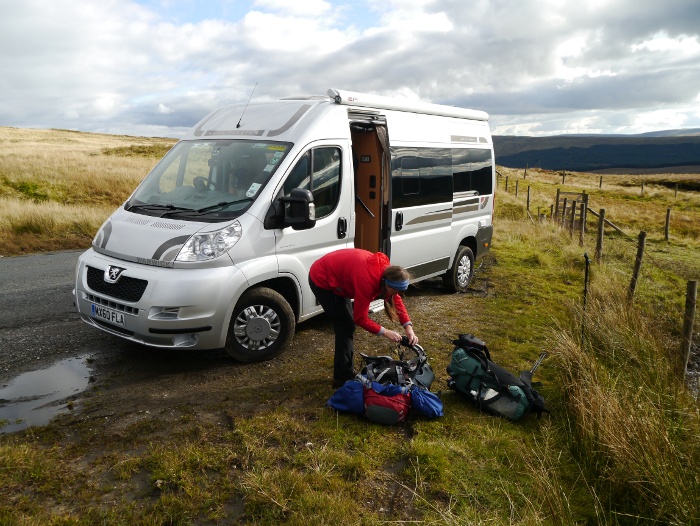
The aim was to meet Chrissie and Geoff at 3.30pm in Horton in Ribblesdale. Unfortunately soon after I got on the M1 the traffic came to a standstill, getting misplaced in Bradford later on did not help my punctuality. I arrived an hour late to be treated to coffee and a home-made cookie in their van just as the skies opened over the Yorkshire Dales. We were gently reminded by Geoff that it would soon be getting dark and perhaps we should be making a move. It was gone 5.00pm by the time Chrissie and I shouldered our packs and set off. The plan was to take a long and indirect route to Ribblehead where Geoff would pick us up a couple of days later.
The empty hills bit in the title? Apart from a couple of runners just after leaving Horton on the Friday we did not see another soul in the hills until Sunday afternoon. Even though we were in view of the famous three peaks all weekend. Maybe the bogs had something to do with that……….
Day 1 – 2.8 miles with 200 metres ascent

It was felt prudent to set off in waterproofs, although the clouds had shifted it looked like rain was not going to be far away. The Pennine way initially follows a walled track out of the village. This meant that progress was rapid and height gain was not really noticed.


Gaps in the clouds meant that the setting sun cast a golden glow on the surrounding hills. The unmistakable shape of Pen-y-ghent was turning a vivid shade of Orange.

The Pennine way branched off to the right to climb towards the summit of Pen-y-ghent. We continued along the valley bottom, a great natural spectacle hidden until the very last minute. Hull pot is a pretty big hole, a waterfall falling over sheer cliffs into its shadowy depths. Something that you really don’t want to fall down. Some of the local sheep though were really pushing their luck, one grazing in a very precipitous position.


We followed Hull Pot beck upstream until it forked, taking the left tributary. Amongst all the rough tussocky ground there was a an area near the stream that gave us a reasonable pitch. It was pretty much dark by the time we got our tents up and the first stars were just beginning to become visible. Chrissie sat just outside my tent whilst we ate dinner but was soon driven back to her tent by the rapidly chilling air.
Day 2 – 8.1 miles with 470 metres ascent

I woke briefly at about 5.00am and stuck my head out of my tent. The showers from earlier in the night had passed and the sky was jet black, encrusted with what looked like thousands of very bright stars. It would have been perfect for a bit of night photography but instead I did the sensible thing and went back to sleep.
The sun had still to rise over Plover hill when I eventually got up. The cold and still conditions meant that my inner tent was covered in beads of condensation and I had to be careful not to dampen my down jacket. Outside there was a light frost and the rain that had fallen on our tents had frozen into mini pools. We spent a leisurely couple of hours around camp, enjoying the warmth of the sun when it finally reached our pitch.


It was 10.30am by the time we finally got moving, picking our way across rough trackless ground. A wall topped by barbed wire intersected our route so we followed it for a while hoping to find a decent crossing. Thankfully there was a gate after a slight detour. A quad bike track then took us up a wide ridge towards the large cairn on the unnamed hill above Cosh Outside.

The views from the large cairn were pretty impressive, the Ribblehead viaduct being visible in the distance under the bulk of Whernside. After a totally cloudless morning, low cloud had started to form on the surrounding high hills. This was now breaking up, adding to the atmosphere and drama of this lofty viewpoint.


Initially the going along the ridge was easy, the underlying limestone meaning that there was soft and springy turf under our feet.

This part of the Dales gives the feeling of large open spaces and in all directions there was high moorland rolling to the horizon.

The ground soon reverted to the usual bog and tussocks along the wide ridge, which we followed to the trig point on Horse Head Moor. The main issue along this obviously little trodden stretch is the intersecting walls and fences, some of which are not marked on the ground. Crossing points were not provided, even on a brand new stretch of fencing. This was rather annoying considering that we were on access land and following the ridge line, a natural linear route. On a couple of occasions we had to climb high drystone walls topped with wire, gingerly trying to ensure the whole lot did not come tumbling down. The going was slow but the wide open spaces and the autumn colours on the hills more than made up for it.


At the trig point it was clear that we were not going to make our intended destination for the night, not during daylight hours anyway. We were still a while away from reaching our chosen lunch spot and it was well past lunch time.

The bridleway down towards Yokenthwaite gave a reasonably solid surface for the descent, a relief after sloshing across wet moorland. The views into Langstrothdale were excellent, showing just how varied the Dales landscape is. We were leaving the high open moors and descending into a limestone dale.


It was 3.30pm by the time we reached our lunch spot, chosen as it was next to a stream to enable us to make a brew. I have recently started to ensure that I make a coffee and cook lunch when backpacking. Couscous being my food of choice as it is quick and easy to make.
After we had packed up we realised that there was less than two hours left before it would get dark, autumn can really catch you out as the days get shorter. My map showed that there could be a suitable ledge for wild camping high above Yokenthwaite, a stream nearby. From our vantage point on the other side of the valley it looked like it may be ideal. We descended down to the road through Langstrothdale, actually rather busy considering its remote location. The dale itself was idyllic, the low sun casting shadows on one half of the valley.

We took a steep track behind the cottages at Yokenthwaite, quickly overheating once we were out of the wind and back in the sun. It had been one of those days that was either too hot or too cold, the sun still providing warmth but the temperature plummeting when in wind or shadow. The track was a stern fitness test at the end of the day.

We left the right of way and started climbing across open pasture, hoping that the ledge identified above would be both flat and out of sight of the surrounding farms and cottages.

It turned out that our chosen spot was pretty much perfect. The ground was flat with short-cropped grass which was thistle free (thistles often seem to dominate what would otherwise be an ideal campsite) and we were totally out of sight. My tent was totally soaking wet from the previous night, the floor and inner a dripping mess. I pitched it and left the door open whilst sorting my kit and walking the five minutes to a stream. Thankfully with a good breeze it was nearly dry by the time the sun disappeared behind the hills. Our wide grassy ledge was fringed by a long escarpment that dropped steeply to the valley below. I soon had a cup of coffee in my hands and wandered along the edge taking in the last of the days light. It’s moments like this that sum up the reason why I go backpacking and wild camping.


We had positioned our tents so that we could chat without either of us getting cold sitting outside. Chrissie was soon asleep and I snuggled into my bag to read my kindle. In the morning Chrissie said that there was snoring coming from my tent. All I can say is that people in glass houses……………
Day 3 – 9.7 miles with 320 metres ascent

Another cold and still night led to an in tent shower when I sat up, my down bag was pretty saturated on the outside due to condensation. I was glad that I was not spending another night in it. We were up and away a bit earlier due to being behind schedule on our route. Some texts with Geoff the night before confirmed that he would pick us up at Newby head rather than Ribblehead, cutting a few miles from the end of the day. He had spent a couple of nights in the van parked on the high road between Hawes and Langstrothdale, we told him to expect us late morning for a tea break!
The ledge on which we had spent the night provided us with a level promenade on which to walk, easy to follow for a mile or so high above the valley. The network of drystone walls and field barns below us was classic Dales scenery.


We followed a series of old National Trust waymarkers which led us up and into Deepdale Gill. At its head it split into two deeply incised streams resulting in a steep grassy contour to avoid loosing any height. We continued climbing higher into this hidden gem, pathless and off the beaten track.

The moor above was well equipped with gates and stiles to get us across the various walls and fences. There was once again a feeling of being in the middle of a large area of uplands and apart from the drystone walls there was no sign of the hand of man in any direction. A collection of boulders gave us the perfect opportunity for a sit down and a snack break.


The going had been easy across what was a predominately grassy moor. The map showed a large flat area around Oughtershaw moor, the view as we approached it confirmed my suspicion that it may be on the damp side.

My expectations were realised and we spent a rather long time not moving very far as the ground became increasingly boggy, deep water filled groughs providing barrier after barrier. It was slow and tiring and we probably covered three times the distance as shown on the map. One false step there could have led to trouble……….


Once again the surface underfoot changed abruptly with firm cropped grass tended by the many sheep.

Woldside was a limestone island amongst a sea of bog, a relief before we plunged once more into peat, groughs and tussocks. We were now above Oughtershaw beck, a wild moorland valley with the isolated farmstead of Cam houses at its head.


In the distance I spotted a figure and two dogs walking towards us, it was Geoff coming to intercept us as once again we were behind schedule. Chrissie did not believe me until she saw Tilly the chocolate Lab bounding towards her. Geoff had parked the van just below the highest part of the road and it was with relief that we got our boots off and sat on some comfy seats. It has to be said that this is the best tea van in Yorkshire and I was treated once again to coffee and homemade chocolate cookies. It was hard to drag ourselves away from the warmth back out onto the chilly moors. We agreed to meet Geoff a couple of hours later where the Ribble way crossed the road at Newby Head.

Walking past the drivers cab I noticed that both the driver and passenger looked a bit canine in nature. Perhaps it was just the relection playing tricks with me?

After a couple of days lurching across rough and boggy moorland, Cam road was a treat for the feet. We made swift progress, enjoying the views without having to worry about plunging into a bog. It had started to cloud up but the air was still very clear and we could see the sea in the distance. What was not so welcome was the view of some turbines behind the bulk of Ingleborough, with the angle of the light they appeared to be very prominent on a distant hillside. The Ribble way was well surfaced and it was all down hill to the road where Geoff was waiting for us. A short drive and I was dropped off back in Horton in Ribblesdale where my car was thankfully still there. An excellent and surprisingly wild backpack in what I often think of as a busy national park.
You can read Chrissie’s version of the weekend here.


