Posts tagged ‘Padjelanta’

October 17, 2014

Into the wild – alone in Sarek and Padjelanta part five

by backpackingbongos

Day nine – 1st September 2014

Day 9

Yet another day dawned clear and crisp, the sun soon drying the heavy condensation on my shelter. My destination for the morning was the security of the well-worn Padjelanta / Nordkalottleden trail. This would then give me an easy and navigation free walk back to the large lake of Akkajaure and the ferry back to Ritsem.

First I had to get off the mountain on which I was camped. With the poor detail and scale on my map I was unsure of the terrain and admit that I had spent part of the previous night worrying about the descent. It turned out to be relatively straight forward, easy to bypass any rocky sections.

P1080255

P1080257

After a few days of rough ground underfoot it was good to be on a proper trail again, even the wooden duck boards were welcome. It’s good to stride out when previously you had to watch every step.

I arrived at the accommodation huts in Arasluokta desperate for a drink of something sweet and fizzy and some extra chocolate to boost my rations. The whole place was deserted and the huts locked, I deposited my considerable pile of rubbish and empty gas canister in the trash room and continued on my way.

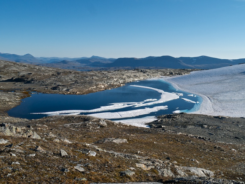
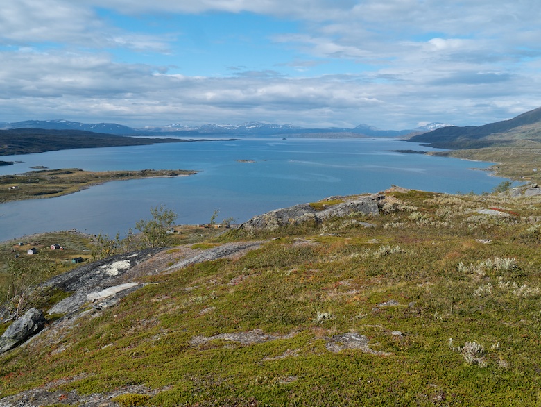
The trail bypasses the main settlement, rising high above it and giving superb views across Virihaure, big enough to make you feel that you are on the coast.

P1080260

The weather during the rest of the day slowly changed, cloud building with a few spots of rain. The trail was almost deserted though, I passed only five people that afternoon.

P1080261

P1080263

P1080265

On the way to Laddejakka the path climbed onto a moorland plateau, the colours of Autumn really beginning to shine. A couple of weeks later and I can imagine that the whole of Lapland would have been spectacular.

P1080266

P1080269

P1080270

P1080275

P1080278

Descending to the north I could see the huts of Laddejakka nestling in the trees at the bottom of the valley. They had been my destination for the night but suddenly the thought of being indoors and amongst people was not very appealing. I had been on my own for far too long.

P1080279

Therefore instead I found a spot to pitch a few hundred metres before the bridge over the river. It was a real challenge to find anywhere to be honest, the vegetation was of the tent shredding variety. I was thankful to find a patch of bare earth.

That evening there was an unusual sound on the fly of the Wickiup, the soft pitter patter of drizzle. Outside it turned cold and grey, murk eventually masking the hills in the distance.

P1080283


Day Ten – 2nd September 2014

Day 10

The drizzle persisted throughout the night and into the next morning. After days of sunshine it was difficult to motivate myself to get going. However once up and outside the conditions were much better than they sounded under silnylon. Tents always exaggerate the sound of rain.

I passed the huts but did not stop to pop my head through the door. It all looked fairly quiet anyway apart from a tent pitched next to a sign saying that there is a fee for pitching.

It is a long and steep climb up the hillside above, here I passed the only person I would see for several hours. I was genuinely surprised at how quiet the Padjelanta trail was. It was only the 2nd September but it was clear that the season had definitely finished. When researching for the trip I discovered that many of the huts would shut at the end of that week. Even the boat to Ritsem would soon stop running until the following summer. The seasons are very short in the far north. I was of course very happy to have what is usually a busy trail all to myself.

P1080285

P1080288

P1080289

With drizzle on and off for much of the day the previously welcome duckboards became lethally slippery in the wet. I think they are called duckboards because you have to waddle to prevent an ankle breaking slip. I often found myself walking off to one side, their only value being for the many Lemmings that run underneath them.

P1080291

P1080294

P1080297

P1080300

The bridge over the Vuojatadno is an imposing structure, I always enjoy the walk over the suspension bridges you get in the wilds of Sweden. The clanking and swaying are always slightly unnerving but in a good way.

P1080302

P1080304

Soon after crossing the bridge I came across a rather strange sight considering I was more than a days walk from the nearest road. There was a caravan with a small generator chugging away next to it. An extravagantly moustached chap leant out of the window to spit as I passed and I tried to engage in conversation. He simply shut the window!

It was evident that they were replacing the bridge over the outflow from Sallohaure. A new half constructed metal suspension bridge standing next to the old wooden one which looks like it needs retiring.

The path to Kutjaure was a bit of a plod but the views back towards Sarek were magnificent, the tops of the peaks just touching the base of the clouds.

P1080308

P1080310

P1080311

I had no plans to stay at the STF hut at Kutjaure but went inside to check the ferry times with the hut host. He was a rather gruff chap who confirmed the times with me. I then asked if the hut marked further along the trail was unlocked and if I was ok to sleep there. His reply was that it is unlocked but it is for emergencies and not for sleeping. I nearly said something about staying there and not sleeping but thought better of it. I said my thanks and left.

I followed what I thought was the trail but half an hour later whilst splashing through bog I finally admitted to myself that I had lost it. My GPS confirmed that I was nearly a kilometre too far to the west. I cursed my lack of attention and spent a while crossing high vegetation to get back on track. All the while the wind was picking up and the skies darkening.

P1080313

After a long climb and on the edge of a plateau I came across a patch of flat grass. With heavy rain looking imminent I decided to stop and pitch for the night. I was glad that I had found somewhere comfortable and with great views for my final night in the wilds.

P1080315

P1080317


Day eleven – 3rd September 2014

Day 11

Heavy rain came in the night, persistent with a strong wind. With no inner in the Wickiup I felt exposed to the elements and found a pool of water developing in a depression in the ground close to my head. Thankfully it was mild and I slept well, enjoying the sound of the rain.

Morning brought no relief from the weather, I was also just below the cloud base, banks of mist drifting past on the strong wind. There was no time to wait for the weather to clear as I had a ferry to catch in the early afternoon. To miss it would mean missing the only bus of the day from Ritsem to Gallivare the following morning. I felt a bit of pressure for the first time since starting out on the hike.

The high level walk along a string of lakes was not very enjoyable, the views non-existent, wind driven rain soaking me through. I was grateful to see the refuge hut appear through the mist. I opened it to find a Swedish couple sheltering from the rain. They made some room for me and shared the coffee they had just made. They were surprised to meet a person from the UK in the hills, most being from Germany. They even joked that there are more German language guidebooks on Lapland than Swedish ones.

I left them and continued my soggy march, it was a case of head down and get on with it. It took two hours at full throttle to get down into the shelter of the birch forest. There sitting on a soggy log under a dripping tree I managed my first call home since the start of the trek. It was good to hear my wife’s voice.

I arrived at the STF hut at Vajsaluokta with over an hour to spare before the ferry departed. The hut host welcomed me in like a long lost friend, gave me a drink and let me wait in the warm and dry kitchen. After wearing the same clothes for ten days I was very aware of my aroma as my body interacted with the warm air!

As the boat came into view the host walked down to the small pier with me so that she could welcome new visitors. I tried to board when it had been tied up but was met by a hostile skipper who told me to go away as they would not be sailing that night. The weather was too bad and he was cancelling the boat. I tried to ask some questions about what to do and he shouted at me to go away. With a sinking feeling in my stomach I followed his instructions and walked back to the hut with the host. She said that the boat had never been cancelled in the years she had been there. I started to panic that I would miss the only bus the following day.

The skipper later came up to the hut and apologised for his rudeness, he said that the weather was so bad on the lake there was a risk to the boat. He had been unable to land at Anonjalmme and had left several people waiting at the pier. He thought that it was unlikely he would be able to leave that evening and planned to go early the next morning. Apparently it was several years to the day when there had been a ‘tragedy’ with the same boat.

A couple of hours later I walked down to the lake and was surprised at how calm it was in this spot.

20140903_171240

I settled down for a night in the hut, unpacked and cooked my dinner. Then suddenly after dark and just as I was about to go to bed I was told that the boat was leaving in five minutes. I stuffed everything in my rucksack and legged it down to the boat by head torch. The engine was already running and the boat left as soon as I was onboard.

There then followed a surreal forty minute crossing in the dark, no lights inside or outside the boat. The skipper would flash a powerful torch every now and then to warn other boats. Finally as we neared Ritsem I was called onto the deck to hold the torch and direct the boat towards the darkened pier. I was pretty relieved to get onto dry land!

It was by then past 10.30pm and Ritsem was in darkness. I got a lift up to the STF huts and the reception was unlocked and I was booked into my own private room for the dorm rate, £10 also knocked off for helping the boat get in safely.

My trek was over, ending in less than relaxing circumstances. What was to me a big trekking adventure had been completed and I was thankfully still in one piece.

A trip of a lifetime. Until next time.

October 12, 2014

Sarek photos

by backpackingbongos

With an afternoon at home I imported my Sarek photos into iMovie, selected some music and it spat out a 1080p video. The final trip report will be up sometime this week and then I’ll stop boring you by banging on about the place.

October 10, 2014

Into the wild – alone in Sarek and Padjelanta part four

by backpackingbongos

Day seven – 30th August 2014

Day 7

When I stuck my head out in the middle of the night the sky was bright with a million stars but sadly no Northern Lights. Although nearly September and sunset being at 9.00pm it was still not getting truly dark. Sunrise was also very early. It was weird to think that by the end of November the sun would set and not rise for a few weeks.

Words can’t properly describe the weather for that and the following day. The sky was blue, the air was crisp, visibility endless, the sun warm and the breeze was cool. It was technically my day off as I had built-in a couple of days slack into the schedule. With weather that good I decided that I would climb a big mountain.

Before setting off I had an alfresco breakfast, sitting with my top off and feeling the strong northern sun on my back was something I had not expected when visiting the Arctic.

P1080163

Daktejagasi had been reduced to a trickle of crystal clear water and I took the opportunity to fill up my water bottles. When it is hot and sunny I often dip my cap in streams to keep cool. In this instance the cold made me gasp.

P1080164

My objective for the day was the 1572 metre peak of Alatjahkka which was just beginning to peek its bald head above the intervening hills. With my 1:100,000 map giving virtually no details apart from contours I was unsure whether it would be easy to climb. This gave a feeling of uncertainty especially as there was a glacier marked on the map.

P1080166

I followed gentle contours up to the summit of an unnamed 1228 metre peak. The views as can be expected were glorious. Taking centre stage were the mountains of Sarek, rocky pyramids pointing into the clear blue sky. The intervening ground was a high plateau of lakes at around the 900 metre contour. An area perhaps worthy of leisurely exploration in the future. I tried to imagine what it would be like up there in the middle of winter in total darkness whilst Arctic storms blasted the plateaus. I could not believe my luck with the weather.

P1080171

P1080173

P1080178

P1080180

I got my first proper look at Alatjahkka, a large dome of rock. From a distance it looked like it would be possible to climb up the middle of the glacier that was marked on the map. On the ground it appeared that the central section of the glacier had melted. I’m not sure if this is due to a general warming trend or simply due to the exceptionally dry and hot summer in Lapland this year.

P1080185

Approaching the glacial moraines I found a rare patch of grass so set about pitching my shelter. Once again it was difficult to peg properly and I even managed to damage a Tornado peg whilst bashing it in with a rock (credit to the peg as the first rock broke before it did). A couple of hefty boulders had to be deployed on a couple of the pegs. A trickle of clear water was collected from nearby so I then sat and had a hot lunch whilst pouring over the map.

P1080192

P1080194

I had packed a silnylon day pack which I filled with spare clothes / torch etc and set off towards the foot of the glacier. I gave a large area of wet sand a detour as it wobbled alarmingly when I stepped on it. I had read that quicksand can often be found at the foot of glaciers. It was not a good place to get stuck!

I followed the stream that was emerging from the glacier, the water was dirty looking being full of sediment. I was glad that I was not reliant on it for my water supply.

The glacier itself was a thing of beauty and I walked right up to its edge, the ice a blue colour as it reflected the sky. There was the sound of water underneath it, cracks and fissures visible on its surface. It would have been fun to walk across but that would have been a stupid thing to do with no glacier experience and on my own.

P1080198

Instead I scrabbled up bare rock, boulders and gravel. Where I was walking should have been covered in tonnes of ice, instead it was as dry as a desert. The previous weight of the glacier has ground some rock into beautiful patterns and crushed others into dust. It was a rugged and ugly landscape.

P1080200

Once above the glacier I passed a deep blue lake, sheets of white ice still floating on its surface, a glacier running up the slopes beyond. A strange sight under the hot sun.

P1080201

The climb to the summit was steep and loose and I took my time to zig zag my way up. I found it difficult to tear my eyes away from the view.

P1080204

There was a cairn marking the summit that showed that others climb the mountain. I was absolutely elated especially as climbing a mountain was not part of my orignal plan. 1572 metres is not very tall compared to other mountain ranges but I was around two hundred kilometres north of the Arctic Circle. The clarity of the air meant that the views were pretty much limitless. There was not a single man-made structure to be seen (apart from the cairn). Mountains spread as far as the eye could see, those to the west in Norway looked just as inviting as those in Sarek to the east.

I sat in the shelter of the cairn to have a snack and then realised that I had left my bag of food on my sleeping bag. I have to say that my stomach was a little disappointed after the physical effort of getting up there.

P1080215

I reversed my route feeling confident that it was safe as long as I took my time and was careful. Once the sun disappeared below the horizon the temperatures on the high plateau where I had camped dipped very quickly.

P1080221

P1080222


Day eight – 31st August 2014

Day 8

I woke in the middle of the night for a call of nature. Sticking my head out of the Wickiup I saw a bright arc of white light in the sky above me. It was not moving and the horizon was blocked by the mountain I had climbed. It was like a sprinkling of stardust in the sky but separate from the stars themselves. A possibility that I had a brief glimpse of the Northern Lights?

It was the coldest night of the trip but not quite enough to give a frost on the shelter. I lay in my sleeping bag and waited for the sun to warm me up. It was another morning of incredible clarity in the air and after burning the day before I smothered my ears and face in factor fifty. The sun was strong enough to wander around camp barefoot and without a top and I relished another alfresco breakfast.

P1080224

The descent to the large lake called Alajavrre was easier than I had imagined and I was soon walking along its northern shore. Its waters looked very inviting for a dip and it was tempting to strip off and dive in. However a hand dipped into its crystal clear waters persuaded me otherwise. It was easy to forget I was in the Arctic.

P1080227

P1080229

P1080231

P1080232

There is a locked Sami hut at the western end of the lake complete with a brightly painted outdoor loo which was also sadly locked. I can’t blame the owners though after witnessing the filthy habits of trekkers at other huts.

Over a small rise and an infant river was picked up. On the map it looked like it would be simple to follow its banks all the way to the huts at Aras. However there is marsh and dwarf willow marked on the map so I decided to keep to high ground. Instead I made a beeline to the small summit of Unna Liemak at 984 metres.

P1080234

I contoured its northern slopes which gave good views back to the lower slopes of the peak I had climbed the day before.

P1080237

I was now in a very different landscape from Sarek. Gone were the long dramatic valleys and soaring peaks. Instead I was in a land of rolling hills, lakes and high plateaus. Reminiscent of the Scottish Highlands I felt much more at home.

P1080239

P1080242

P1080244

P1080247

With the weather remaining so good I decided to have one more high camp before joining the Padjelanta trail. I therefore decided to climb Stour Djidder and camp near its summit.

One thing you do not expect in Lapland is for streams to be dried up. It ended up taking ages to find a spot that was flat and dry with no tough vegetation and close to running water. Being above the massive lake of Virihaure it felt like I was wild camping on the west coast of Scotland. The similarity from my camp spot was striking.

P1080248

The sunset that evening was spectacular. Sadly it was the last one of the trip. The weather was about to take a turn for the worse.

P1080253

October 5, 2014

Into the wild – alone in Sarek and Padjelanta part three

by backpackingbongos

Day five – 28th August 2014

Day 5

There was the real temptation to stay put for a few days and return the way I had come. Campsites that good are few and far between and it would have been nice to climb some of the surrounding mountains. However with my pack beginning to reduce to something resembling a manageable weight I decided that I would continue onwards and see what else Sarek has to offer.

There is a hut with an emergency telephone close to the bridge over the Mihkajahka, although not designed for overnight stays it would be very welcome in bad weather. There is even a rather smelly toilet next door. Sadly despite a sign asking people to carry their rubbish out there were a few empty freeze-dried meal packets and gas bottles on the shelves. A real shame.

My route to the west looked much simpler on the map than it does on the ground (the beauty of a 1:100,000 map) and I quickly lost the path. Animal tracks tempted me to descend too far and I ended up floundering through bog, boulder and dwarf willow. A few hungry mosquitos added to the general cursing for an hour or so until I got back on track again.

Although not named as such I was at the headwaters of the famous Rapa valley and the scenery was sublime. I think that Sarek trip number three will involve a full traverse of this challenging valley.

P1080083

P1080087

P1080089

The trail when I found it was often faint and would disappear from time to time, especially through the areas of dwarf willow and bog. After the well trodden Ruohtesvagge I felt that I was getting into something resembling true wilderness.

P1080094

P1080096

P1080098

The Guohpervagge was the second river of the trip that involved an Arctic foot spar. The glacial river was narrower this time which meant that the current was a little stronger. In wet conditions it would probably be prudent to walk upstream to where the maps shows it braids into channels.

The path then changes direction, passing a couple of huts on the other side of the river which are possibly used by the Sami reindeer herders? As the watershed was reached the ground became much rockier and I had to pick my way carefully over moss covered boulders. It would be very hard going in the wet.

P1080102

P1080105

P1080106

P1080107

On the map it is difficult to work out the exact position of the watershed. On the ground it was much easier, once water started flowing in a different direction I had crossed it. I had reached the Alggavagge valley which I would follow to the lake at its foot and exit Sarek National Park. I had been told that in the lower reaches decent camp sites could be difficult to find and that the dwarf willow could be a challenge. I soon came across a flat and very lush area of grass that was screaming out at me to pitch my shelter. There was even a bank giving protection from the wind. Although it had been another short day I succumbed, reasoning that it would only take me a couple of hours in the morning to get back on track.

P1080110

P1080113


Day six – 29th August 2014

Day 6

It had clouded over during the night and it had felt like rain was in the air, I was therefore pleased to wake to a cloudy but dry morning. For once I got up early, keen to make up the distance from a lazy afternoon in camp.

I was keen to see a lemming so it was a bit sad that the first I would see had recently died on the path. I don’t really know anything about lemmings apart from a 1990’s video game where they jump off a cliff. The are cuter and furrier than I thought they would be.

P1080116

I made quick progress down the upper reaches of the valley. Even though the path was narrow it took me across the easiest ground as it wound its way through both pleasant grass and troublesome vegetation. The valley is much narrower than Ruohtesvagge, the peaks towering above. The long grass in the marshes had began to turn yellow which contrasted with the black rock of the mountains. Once again pictures are better than words.

P1080119

P1080121

P1080123

P1080126

P1080127

P1080129

As I approached the eastern end of the lake Alggajavrre I started to contour up the hill in search of an easier way through the increasingly dense dwarf willow. I ended up picking up another narrow path that led me easily through the worst of it. it was a section that I had been dreading so was glad to get through without too much cursing. I was around eighty metres above the lake and eventually reached easy ground on a level with the Sami chapel, the path heading directly for it.

P1080131

This simple stone structure from the outside could have been a bothy lifted directly from the Scottish mountains. It initially looked like there had been a fire as the area around the window, door and ground was all blackened. Closer inspection showed that it was actually a tar like substance which had melted off of the roof. It was obviously not designed for weeks of summer weather where the temperature had often reached 30 celsius.

P1080139

Inside it was a very basic but charming chapel. I sat and chatted for a while with a solo German hiker who was also fulfilling a long time ambition to experience the wilds of Sarek.

P1080135

I rested and continued chatting for a good half hour, the surrounds of the chapel were a good place to linger. The sun had finally come out again and a cool gentle breeze blew patterns through the long golden grasses. It was all very idyllic.

P1080137

High up the Gainajjagasj would have been too difficult to cross. Therefore I descended to attempt it where it splits into channels before entering the Mielladno. It was the third and final time that I would need to remove my boots for a river crossing on the trip. The water was just as cold as on the previous two occasions.

P1080148

The Mielladno is a sizable river and there is a bridge marked on the map just to the north of where the Gainajjagasj enters it. I was therefore rather concerned to discover it was not there. In fact there was no sign that it had ever existed. After a bit of searching I finally found it about a kilometre downstream. I have to say that it is rather sloppy map making on Calazo’s behalf. It was clearly evident that the bridge has not just appeared in the last couple of years either, so no real excuse to get that wrong. The bridge itself was in a very sorry state, rusted and with a great heap of it now sitting on the bank of the river. Much of the hand rail was now missing, bits of string replacing it. It was a nervous backpacker who crossed the creaking and wobbly thing. I probably would have taken heed of the notice at either end if my Swedish was up to scratch.

P1080149

Crossing the river meant that I had now exited Sarek National Park and entered Padjelanta National Park. I was looking forward to seeing how they contrasted with each other.

The next section of the route was the one that had me most worried during the planning stage. I was now leaving the security of the long Sarek valleys and was about to head west across a high lake studded plateau. Thankfully my visions of being blasted by wind and rain whilst trying to navigate on a 1:100,000 map in thick mist did not happen. My climb that evening up to the 900 metre contour was in warm afternoon sunshine.

P1080151

As evening approached I began to worry that I would not find a suitable place to pitch my shelter. The ground was either bog, thick prickly vegetation or rock. I was therefore pleased to find a small patch of passable ground. My pegs just about held my shelter up as there was only a thin layer of dry crispy moss over gravel. In such an exposed spot I hoped that the wind would not pick up during the night.

P1080157

P1080160

I went to bed a very happy man. I felt that it had been the best day of the trip so far. I had covered a reasonable distance and passed though a potentially tricky area with ease. Camped high with an uninterrupted view of the northern horizon I set my alarm for the middle of the night, I felt optimistic that I might see the northern lights. Before going to sleep I had a good look at my map, perhaps I would have an opportunity to climb a mountain the following day if the weather remained good?

September 27, 2014

Into the wild – alone in Sarek and Padjelanta part two

by backpackingbongos

Day three – 26th August 2014

Day_3

It took a while to get used to the roar of the nearby river during the night. At times I thought that it was the wind and found myself tensing up ready for it to hit the tent.

With the knowledge that I had two easy days it front of me I felt relaxed when I woke up, aware that there was no sense of urgency and need to rush. Sticking my head out of my shelter the first thing that I saw were a couple of reindeer on the bank above, their antlers silhouetted against the sky. I truly felt that I was somewhere special and far away from home.

The walk to the old Sami hut at Kisuriskatan was along a narrow but well defined path, this inspired confidence in me as I moved further away from civilisation and towards my first taste of wilderness. The reality is that this route into Sarek is one of the main highways, it gets a lot of foot traffic during the brief summer. This is probably due to it being the easiest way into the centre of the National Park. Despite this I would not see anyone else until the end of the day.

The Sami hut was a traditional affair, made out of wood and turf, the roof now mostly open to the elements. It would however make a reasonable lunch shelter during bad weather. Unfortunately previous visitors had felt the need to leave a couple of bags of lentils and mouldy onions, neither doing well whilst exposed to the elements. A lazy attempt to lighten a pack rather than an act of altruism.

P1070963

P1070968

Passing through a marshy section the path began to climb a little, the ground becoming stony. A herd of reindeer were close by watching me wearily, occasionally running away before deciding that I meant no harm and coming back again. I removed my pack and sat in the sun for a while and watched them. They are not the worlds most exotic animal and are in effect livestock, but added with the scenery I did have one of those National Geographic moments.

P1070979

The day was dominated by the impressive mountain of Nijak which is 1922 metres tall, from some angles appearing as an impossible pyramid. From others it resembles Bowfell in the Lake District. Ahkka which I had passed the day before was still a huge presence behind me. The view of it was constantly changing and it is more of a mountain range rather than a singular peak.

P1070983

P1070985

P1070992

20140826_150021

P1070995

P1070996

P1070998

Thankfully there were no challenging river crossings that day, my boots were kept on and I hopped across every one with totally dry feet. Even the main Nijakjagasj would have been possible to cross dry-shod if I had needed to.

P1080001

As I started to look for a place to pitch I spotted the first people of the day, a couple had bagged a lovely spot above the river for their tent. I continued on for a while, for me wilderness etiquette means that you should not pitch near others unless invited. I soon found a wide open area of short-cropped vegetation surrounded by incredible views. The dry crispy ground did not hold my pegs very well and I had to resort to some hefty rocks on a couple of them.

I spent the evening watching several people climb up along the stream called Nijakvagge to the south of Nijak. I could not work out if they were camping but they spent an eternity milling about below the cliffs. Perhaps they had climbed to watch the sunset which was catching the surrounding mountains on fire. The setting sun was hidden from me but the colours were warm as the temperature dipped. A cold breeze was noticeable in my shelter without a solid inner. I was glad of my bivy that night.

P1080006

P1080008

P1080010

P1080011


Day four – 27th August 2014

Day_4

I had been eyeing up the 1004 metre peak of Ruohtesvarasj on my map before leaving home. It sits on the watershed of two impressive valleys, rising one hundred metres above them. Laziness that morning meant that I continued on the path around it.

P1080018

P1080019

I had not expected the hut marked on the map next to a trio of lakes to be unlocked. It looked like that at some point the lock that held the hefty bar across the door had been broken. The location would put just about every bothy in the UK to shame, it is very special. However what I found inside was rather depressing. The space to the left of the door in the porch was piled high with rubbish. Much of this was empty packets of freeze dried food (Real Turmat being the most popular). It was a stinking fetid mess, obvious that passing folk thought that it was ok to add to the pile. Two metal barrels outside were also full and rusty fish cans lay discarded next to them. The mess inside I would estimate would fill ten black bin bags. With no motorised transport inside the National Park I don’t know who these people expect will clear up after them.

Seriously, who thinks that it is ok to walk a few days into the wilds and then dump their rubbish? I’m sure the same people would be horrified by anyone dropping litter, but tucking it out of the way in a hut is ok if no one spots them doing it? Strangely the sleeping section in the hut was swept and spotless.

Talking about litter I have another quick rant to get out of my system before we continue on our journey through Sarek. Throughout my walk along the paths of Sweden I came across various bits of tissue paper blowing in the wind (usually behind a boulder that I had chosen as a spot to sit down out of the wind). I did not examine all those bits of paper very closely but they were always clean and there were no sign of faeces nearby. I will therefore lay the blame squarely on the opposite sex. Just give yourself a shake after having a pee, if you feel the need to wipe then take the paper with you. Thanks.

P1080022

I had a good old internal grumble as I headed away from the hut, feeling much better by the time it was out of sight. Seeing a large glacier curve its way down between two dark rocky peaks soon had me smiling again.

P1080028

Being at an altitude of 900 metres meant that the vegetation was short and crispy, perfect for backpacking.

P1080029

P1080030

A section of marsh and the sound of a river signalled that I was approaching the glacial river of Smajllajahka, one which I was worried would be difficult to cross. The dry weather meant that I got across the marshy area without getting covered in muck. I was then faced with a huge gravel plain, the river split into several braids. There were three main channels to cross, the water milky with glacial sediment which meant that I could not see the riverbed. The first was crossed dry-shod with a combination of rock hopping and a bit of faffing. The second would have meant a boot full of water so they were removed and I changed into my Inov8 Recolite 190’s. I can tell you this, water in glacier fed rivers is cold. I may have made some funny noises whilst crossing.

After crossing the third channel I was very glad that it was sunny whilst I sat on a boulder to both dry and warm my insulted toes.

P1080035

P1080037

P1080038

Although I had seen a few people since arriving in Sarek they had all been from a distance. Therefore I was quite pleased to see four figures approach me, even a misanthrope can be up for a chat after being alone for a few days. I was therefore rather disappointed when the family passed me with barely a grunt and without making eye contact. Maybe I need to conceal the wild-eyed look.

P1080047

P1080052

P1080054

P1080058

It is not very often when backpacking that you find ‘the’ pitch. I found it where the Mihkajahka meets the Smajllajahka, a more perfect spot I cannot imagine. Flat, dry, grassy, close to water and a view that makes you pinch yourself every few minutes. It had taken me four very easy days to get there, but with a light pack most fit backpackers could probably make the fifty kilometres in two. The Sarek superhighway makes getting into the centre of the park pretty easy. I still can’t get my head around why the place was not teeming with tents.

I think that a few photos can speak louder than my words can.

P1080067

P1080070

P1080072

P1080073

P1080074

Unfortunately the going would not be quite as easy the following day.