These days Reuben is quick to work out when I am getting ready for a backpack. The pile of gear and boots by the front door being the most obvious clue. Unfortunately on this occasion he was left to sulk in his bed. The North Pennines are one of the least dog friendly hilly parts of the UK. There are plenty of footpaths where he can walk but much of the access land prohibits dogs. This is mostly to do with disturbing grouse which are due to be blasted out of the sky in less than a month. I did try to explain this to him but he said that it defied common sense. What do dogs know?
Total distance – 47 kilometres with 1045 metres ascent

Day 1 – 14 kilometres with 460 metres ascent
There are no restrictions on leaving a vehicle overnight at the car park near the Bowlees visitor centre, so that’s what I did. As I was getting ready I looked on jealously as a woman opposite fried some fish and then fed some returning walkers. I put on my hungriest face but she barely glanced my way.
Bowless gives quick and easy access to Low Force, which is a picturesque spot but not at its best during a dry spell in summer. I was heading towards the end of the road past the small hamlet of Holwick. The meadows were a riot of yellow, a beautiful sight under the steely grey sky. They are great to look at but soon had my nose streaming as the hay fever kicked in.
I had my sights on the unremarkable summit of Bink Moss, a 2000ft Nuttall which has eluded me for years now. To be honest it has not really eluded me, I have just avoided it. Looking at the map it does not scream out, ‘Climb me’. The ascent turned out to be easier and more pleasant than anticipated. A good path took me up Holwick Scar and onwards to Rowton Beck, the air full of the calls of Curlew and Golden Plover. I then followed a wall or fence over moorland to the summit (I have no recollection if it was a wall or fence, my memory has erased that detail). With not much in the way of stones or boulders in the vicinity the summit is marked by a post with a welly on top. I think that was the summit but just to be sure I wandered around onto various lumps and bumps just to be sure. It’s that sort of exciting place.
After another trackless moorland jaunt the large cairn at the wonderfully named Hagworm hill was reached. The plan had then been to take the non-existent right of way to join up with the bridleway across Cronkley fell. With a bird’s-eye view the going looked like it would be grim. Therefore I decided I would climb up onto the summit of Long Crag and cobble together a route from there.
Once on the extensive plateau the going was easy with a faint path along the northern edge. I soon ran out of access land and found myself face to face with the Warcop range. I then mounted a minor incursion and snuck across the line, heading for Merrygill Beck to get back to where I was allowed to be. A sense of wrong doing added a little excitement to this excursion and there were great views from the northern tip of Long Crag. Mickle Fell looked tempting but I thought that would be pushing my luck. I will leave that for a non firing day.
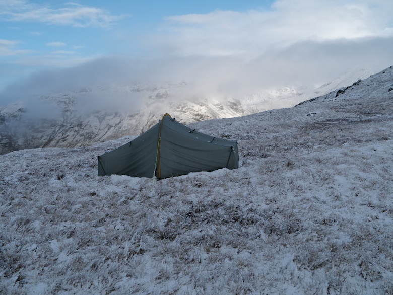
After collecting water from Merrygill Beck I pitched just above the River Tees, a light breeze just enough to keep the worse of the midges away. The view as I lay in my sleeping bag after dinner was superb.


Day 2 – 19.5 kilometres with 445 metres ascent
There was a fine drizzle in the night which may have been midges attacking silnylon. I did not open up to investigate fully. Instead I shivered in a new Montane Prism sleeping bag which I bought to take to Arctic Sarek in a few weeks time. It has since been returned for a refund, heavier and not as warm as advertised.
After packing up I followed a delightful stretch of the River Tees along its south bank, all the time looking for a place to cross over to the Pennine Way. It would have been easily wadeable but would have meant boots full of water. Instead I continued upstream and crossed the nearly empty Maize back, Cauldron Snout thundering nearby. It’s always an impressive sight.
Once I had climbed up to the dam it was a very long trudge along the track on the east side of Cow Green reservoir and all the way to the summit of the B6277. Once the reservoir has been left behind there is a shooting hut which has an unlocked room at the end. This provided a good excuse to get the stove on for a coffee and a big pile of fig rolls.
The track allowed for quick and easy progress, Cross Fell beginning to dominate the landscape as I got closer. There is a real sense of space and although not wilderness it’s about as wild as you can get in England on these moors. As if to emphasis this it started to rain for a while.
The road with its fast traffic was a brief intrusion in the feeling of being somewhere remote. I simply crossed it and started climbing towards the summit of Burnhope Seat. A line of grouse buts gave a feature to follow but I was dismayed to come across several empty bags of animal feed discarded on the moor. Pretty poor and lazy land management in my eyes.
I knew that the trig siting on its large concrete plinth does not mark the actual summit of Burnhope Seat. This lay across a very boggy stretch of moor which had to be crossed twice.
With cloudy but settled conditions I decided that I would spend the night pitched right on the summit of Great Stony Hill. To get there I had to cross a great swathe of moorland with various disused mine shafts dotted about. I have to say that I have a fear of falling down a deep hole and not getting out again. I paid close attention to where I was going and was almost disappointed that I did not see any bottomless pits.
Great Stony Hill has a few stones scattered around its grassy summit, I’m just not sure that it qualifies it to have the words great and stony in its name. I pitched on a flat area of close-cropped grass, keen to ensure that the pegs were secure in such an exposed spot. Water was collected from a nearby small tarn and filtered. An unexpected bout of wind and rain then lay siege to the tent so I hunkered down to read my Kindle. A break in the weather led to impressive skies, dark clouds lit up by shafts of sunlight. The weather then closed in for the night, rain singing on the flysheet all night. Clouds descended leaving me in a grey swirling world. I kept half an ear out for thunder, ready to flee with only a hint of it approaching. Thankfully it did not.


Day 3 – 13.5 kilometres with 140 metres ascent
It was another cold night, especially considering that it was close to mid summer. The mist had dispersed by the time I had packed up and set off. I passed more old mine workings and what looked like an unfenced shaft at the bottom of a depression in the ground. I decided against having a closer look.
The summit of Three Pikes is located across moorland that can be best described as boggy and peaty. Progress was slow as I worked my way between many hags, luckily the peat had dried enough not to be the dreaded black ooze that tries to remove boots. A fine cairn overlooks Harwood, a good place to rest and listen to the sound of summer on the high Pennine moors.
The actual summit was located before dropping down into the headwaters of Langdon Beck. This was followed downstream before climbing to High Hurth edge along the boundary of access land. Dropping down into pasture I had to pass a large herd of cows with calves. Aware of the potential danger I skirted along the edge of the field rather than follow the path through the middle of them. One gave me a cold hard stare.
Tracks and lanes led back to Bowless where I was tempted into the visitor centre for a bite to eat. I left with just a can of drink as I baulked at the price of a sandwich. I decided to drive home powered by left over fig rolls.