Archive for April, 2015

April 27, 2015

Geoff’s Lands End to John O’Groats

by backpackingbongos

On Friday my friend Geoff will be setting off north on a long journey between Lands End and John O’Groats. A shiny red bicycle will be his mode of transport for the thousand odd miles. He will be travelling solo and unsupported, carrying his camping kit along the way. I don’t cycle but I reckon that means he will be heavily laden. He’s also something like 17 in dog years too………..

His blog will be worth a follow and I’m sure that he will be tweeting his progress as he makes his way up country. Cheer him along the way.

http://farnotfast.blogspot.co.uk/

@GeoffCrowther1

He’s fundraising for Cancer Research so if you fancy digging in your pockets you can do so here.

April 19, 2015

Newtondale – backpacking the North York Moors

by backpackingbongos

Navigating the steep hairpin bends between Lockton and Levisham made my stomach flutter with a bit of excitement. It wasn’t the angle of the road but the fact that I thought that a new series of the League of Gentlemen was being filmed. I’m almost certain that I passed Tubbs and Edward standing by the side of the road decked out in grubby Barbour. Sadly it turned out that they were just supporters of the local hunt, which was being led by a man with the reddest face imaginable.

Levisham turned out to be a delightful village, basically a long village green backed by beautiful stone buildings with a pub at the far end. The only road in and out is the aforementioned country lane which plunges down to Levisham beck before climbing out the other side. I bet it gets cut off a lot in winter.

We took a track to the right of the pub after Reuben was saddled up and the car abandoned on the main street. We were passed by several vehicles heading into the village. Where they came from I have no idea as the track ends on rough open moor. The occupants of every single vehicle pointed at Reuben as they passed, perhaps they have never seen a Staffie wear a pair of overstuffed panniers before?

I had read somewhere that the Hole of Horcum is the Grand Canyon of Yorkshire. I have never visited the Grand Canyon before but I feel that there may have been a bit of exaggerating about the Yorkshire version. It is a very nice spot though and I was glad of the shelter it provided from the strong and cold wind. I would give it a few more extra points if the busy road to Whitby did not run along its eastern edge.

P1090004

P1090005

A steep climb to the north led us up to the lip of Yorkshire’s Grand Canyon. There we were able to turn our backs on the hustle and bustle and head across the moors towards Newtondale.

P1090009

It was only my third visit to the North York Moors and I am beginning to work out the parts of it that I enjoy. The moors themselves are dreadfully dull, a flat monoculture of heather criss crossed by land rover tracks. Nothing really to invigorate the senses or lift the soul. The word sterile comes to mind. The contrast with the various dales however could not be starker. These are full of life, trees clinging to steep slopes, lush vegetation and a feeling that they are somehow wilder. Quite the opposite to many other upland areas I find.

I enjoyed the walk down into Newtondale immensely.

P1090010

P1090012

The North York Moors Railway runs its way through the dale, although the trains had not started running this early in the spring. All was quiet with not a soul to be seen in this reasonably isolated valley.

P1090019

After following a forestry track north for a while we struck directly up steep slopes once past the plantation. I’m glad that the bracken was still brown and crunchy underfoot. In summer our chosen route would be simply impossible. You would also probably end up covered head to toe in ticks.

P1090020

A squelch across the flat moors and an idyllic spot was found next to the infant Blawath Beck. It was flat, dry and covered in springy moss. Although early I did not hesitate in getting the Trailstar up, I’m someone who does not pass by a good pitch. Reuben seemed happy with the chosen spot, as soon as his panniers were removed he was pulling his best breakdancing moves.

It was a pleasant evening chilling out with my kindle, listening to the first snipe of the year drumming somewhere overhead.

P1090023

P1090025

Despite a night camped next to a stream there was zero condensation when I woke up. The sun had finally come out and the air was alive with the sound of bird song. It was tempting to have a lazy morning enjoying camp but I’m sure that wild camping in the North York Moors is probably frowned upon.

The pastures around Wardle Green contrast nicely with the austere moors and regimented conifer plantations. The old farm is surrounded by Scotts Pine and broadleaf trees. An oasis buzzing with life on an early spring morning.

P1090026

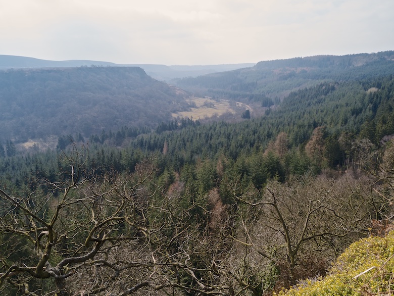
A bridleway and forestry track led us to high above Newtondale, a fine path leading along the edge of Killing Nab Scar. It’s probably one of the finest paths in the country as it winds its way high above the dale giving splendid views down into the valley. It was a shame that a haze had built up.

P1090029

P1090033

A bench had been handily placed in which to enjoy a rest in the sun and drink in the view. All morning I had heard the buzz of trail bikes somewhere in the forest. All of a sudden half a dozen came tearing down the path I had just walked. I had to hold Reuben tight as they passed in front of the bench, inches from us. In my head I challenged them, waving my fist until they saw the error of their ways. In reality I just sat there glumly and nodded my head as they passed.

P1090038

A steep path took us down into the valley and then past Newtondale Halt. Climbing once more up the steep southern slopes there was a section that involved the use of steps built into a rock face.

P1090039

P1090041

Although not marked on the map there is a narrow trod that continues on past Yewtree Scar and all the way to Skelton Tower. Another grand promenade, equaling the path earlier along Killing Nab Scar.

P1090042

P1090047

Skelton Tower occupies a spot close to the steep drop into the valley, feeling much higher than 170 metres. It provided a place to sit out of the wind and rest before the final mile or so back to the car.

P1090049

P1090050

I think I am going to have to make more of an effort to visit the North York Moors. They are a much quieter alternative to the Peak District with not much further to travel.

April 12, 2015

Sheffield Pike and Glenridding Dodd

by backpackingbongos

Ullswater should have come with a health and safety warning that morning. It was hard to keep my eyes on the road as I drove the Bongo towards Glenridding. The waters were mirror calm with a low dense mist floating above the water. I parked in a lay-by and watched a succession of people stop, jump out of their vehicles and take a quick photo. A few gave me a big thumbs up with a smile on their faces. It does look odd when people take photos with full sized iPads though.

P1080908

7.5 kilometres with 580 metres ascent

Screen Shot 2015-04-12 at 14.31.00

Starting from Stybarrow Crag we followed the lakeside path towards Glenridding before taking a track that rises above the village. I totally failed to find the start of the path that zigzags through bracken onto Glenridding Dodd. Spotting a couple and their dogs high above I nipped between a row of terraced cottages and bashed my way straight up the hill. Thankfully I intercepted the well hidden path higher up. The strength of the sun along with no breeze meant that Reuben and I were soon panting, my heavy paramo relegated to my sack. The mist from the lake was drifting south down the valley, obscuring the village below but magnifying the sounds.

P1080911

Glenridding Dodd was quickly and easily reached, providing a superb viewpoint down the length of Ullswater and along to the snow clad Pennines on the horizon. My next destination Sheffield Pike looked much higher and steeper than the map suggests and I stood and picked out my route up to Heron Pike on the skyline.

P1080912

P1080915

P1080917

We returned some of the way that we had come before attacking the steep eastern slopes. A narrow path led up easily though the heather and rocks and I stopped frequently to take in the views. With every step Catstye Cam and Helvellyn grew in stature, the late winter sun giving texture to every snow filled rake and gully.

P1080920

P1080924

We were soon at the top and admiring the onward route up the Dodds, hills we had walked the previous day. It was tempting to continue and spend the whole day on the fells. However I wanted to be back at the Bongo and driving home before lunch time.

P1080928

P1080929

The path that descends to the north high above Glencoyne was much trickier than anticipated. The narrow path was compacted snow and ice above some steep and long snow slopes. Typically I had taken ice axe and crampons with me on the previous two days and not needed them. On what I though was be a shorter, lower and easier walk they would have come in handy but were sitting uselessly in the van. I picked my way along gingerly making use of previous footprints for security, thankfully not suffering any slips or mishaps.

P1080930

Three hundred metres lower and into the woods I crossed into another season, spring was definitely in the air. It was a warm and pleasant walk back to the Bongo and a long drive home.

April 11, 2015

My 2015 TGO Challenge route

by backpackingbongos

This is a cracking route, one of the best I have vetted for the 2015 Challenge, and you have mixed big hills with lesser ones, have stayed away from the main Challenge highways and have not been afraid to go cross country, your route sheet has been a pleasure to follow and your F.W.A are spot on, good on you.

I love a bit of praise I do and the above comment from my TGO vetter made me puff out my chest with pride! Mind you they may say that about everyone’s route………..

Four weeks today and I will be on day two of a backpack from the west coast to the east coast of Scotland, with hopefully the sun shining and a cool breeze caressing my back. I thought that I would do a quick blog post outlining the route that I have decided to take.

The total distance is 309 kilometres (192 miles), plenty enough for me over the space of a couple of weeks. The plan is 8 nights wild camping, 1 night in a bothy, 2 in a campsite (one is the village green in Tarfside) and 3 in Hotels / b&b’s. I’m going to send on a couple of parcels with main meals that I have dehydrated myself (being veggie the pickings can be slim in rural Highland shops) and pick up snacks locally. I only actually pass two places that have a shop anyway. The nights in hotels give me a chance to shower, rinse out some clothes and have a proper dinner and breakfast.

When planning a long backpack I always find it easier to break the route down, it then seems less daunting. The maps below show both the main and foul weather alternatives.

Part one sees me walking from Oban to Kinloch Rannoch with the opportunity to take in a couple of Munros and a scattering of lower hills. I have never visited Gorton bothy visit so am looking forward to stopping there for a night.

Screen Shot 2015-04-11 at 12.06.07

(You can click map to enlarge)

The section between Kinloch Rannoch and Braemar is the wildest of the trip. I’m looking forward to exploring the Headwaters of the Tarff. Some lonely and remote country there.

Screen Shot 2015-04-11 at 12.08.36

(You can click map to enlarge)

The final section between Braemar and Inverbervie sees me joining the Challenge trade route. I’m hoping to take in a string of Munros around Lochnagar, the weather has never been good enough on previous crossings. From Tarfside I have decided to avoid the usual route to Edzell and St Cyrus. Instead a final push over low hills to Fettercairn before a slog along roads to Inverbervie and fish and chips.

Screen Shot 2015-04-11 at 12.10.02

(You can click map to enlarge)

I just now need to get a bit fitter!

April 7, 2015

A fond farewell to the magnificent Monadhliath

by backpackingbongos

I stood under blue skies and hot sun, after stopping to strip down to just a baselayer. A welcome relief after three days of freezing temperatures and limited visibility. The high plateau stretched into the far distance, every gully and hag of the brown moor still filled with snow. For a while I was transported back to Arctic Sweden, such was the scale of the scene. It was day four of a solo backpack and I had yet to see another human being.

The Monadhliath have long held a magnetic draw for me, unlike any other place in Scotland. It is predominantly moorland in nature, although in places it does rise above the magic 3000 feet. High plateaus split by long lonely glens, perfect for the backpacker.

My attention for five days over the Easter weekend was a leisurely exploration of the area where the consented Stronelairg wind farm will sit. 67 huge turbines along with miles of new roads, pylons to connect it to the grid and a potential substation near the historic Garva Bridge. The turbines will occupy a site the size of Inverness. This past weekend though it was just me, numerous golden plover singing their hearts out and mountain hare still in their winter coats. It’s heartbreaking to think that it will soon be covered in concrete and steel, the whooshing of blades replacing bird song. There is a possibility that the John Muir Trust will win their appeal, but I don’t hold out much hope.

In a way this was my final farewell to a fabulous area, a place that gives a feeling of freedom and space that is hard to find in this crowded Island. Goodbye dear Moanies, it was good to meet you whilst you still had a beating heart.

I’ll do a proper trip report at some time, in the meantime just a few photos and words.

Looking into the heart of the proposed site, a high plateau all above 600 metres. Taken from the summit of the Corbett Meall na h-Aisre.

P1090074

Camped at 670 metres bang in the middle of the extensive moorland plateau. You can just make out one of the wind monitoring masts right of centre.

P1090078

The still frozen Allt Creag Chomaich. In summer the joy of the Monadhliath is following the grassy banks of the numerous watercourses. This time the going was treacherous with snow covered bog to snatch the unwary.

P1090086

Looking north from the summit of the Corbett Gairbean across the rapidly melting snow fields on the plateau.

P1090142


There is currently a worthwhile petition, Save Loch Ness and the Great Glen. Please sign it.