Posts tagged ‘Arctic circle’

December 10, 2017

The Arctic Trail – Kautokeino to Kilpisjärvi pt3 (mist and misery)

by backpackingbongos

The Arctic trail starts at Kautokeino in the far north of Norway and heads south for approximately 800 kilometres. It crosses into Finland and Sweden, finishing either in Kvikkjokk (Sweden) or Sulitjelma (Norway). To confuse things the trail has a different name in each of the countries through which it passes. In Norway it is called the Nordkalottruta, in Finland the Kalottireitti, and in Sweden the Nordkalottleden. In English it is simply called the Arctic Trail as the entire 800 kilometres are above of the Arctic Circle. Not to be confused with the Arctic Circle Trail, which is in Greenland!

Part one can be read here.

Part two can be read here.

Pitched above 650 metres I was exposed to the wind that increased during the night. The rain was intermittent to start with but by morning it had gained some urgency, flying horizontally across the open hillside. As I was packing I heard a shout and stuck my head out of the tent and was greeted by five waterproof clad guys, rucksack covers flapping over huge packs. A quick conversation established that they were heading to Kilpisjärvi, my final destination. They were in high spirits and I watched as they climbed the hill beyond my tent and disappeared into the mist.

After enjoying mornings of being able to pack outside the tent under blue skies and sunshine, it was no fun doing so in the confines of the Enan. A mass of wet flapping nylon was then wrestled into its stuffsack and off I set into the wind and rain.

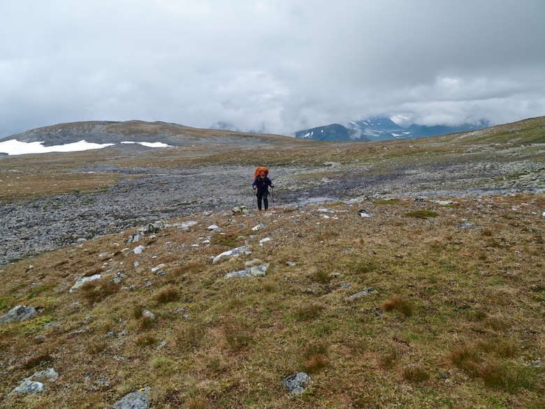
This was the day where I was hoping for good clear weather as the trail contours high along the hillside, staying above 800 metres for a few miles. I could sense the space to my right, the map indicating a huge drop to the valley hidden in the mist. With the wind blowing the rain directly into my face it was a matter of putting my head down and getting on with it.

In some ways I was enjoying the grimness of it all, after days of freakishly perfect weather it was good to have a bit of variety. I marched along with the aim of getting to a warm dry hut by the end of the day.

Sometimes it’s easy to get lulled into a false sense of security and forget just how remote the area is that you’re in. Accidents can happen so quickly and when they do you realise just how vulnerable you can be as a solo hiker. Easy angled slabs surrounded what looked to be a pretty innocuous stream. I literally put one foot down and instantly I fell heavily on my side, my arm pinned underneath me. I don’t know what hit first, the pain or the shock. I lay on the wet rock for a while, unable to move due to my heavy pack. I had dropped my hiking pole in the stream and watched as it started a slow descent towards the sea. Luckily I managed to stop it with my foot by sliding further down the slab, and then escaped from my rucksack which was holding me down like an upended tortoise. I sat there for ages, horrible pain in my upper arm whilst I continued to be battered by the wind and rain. It’s the loneliest that I have ever felt in the hills.

It took a while before I dared move my arm, thankfully everything moved ok and any prodding did not hurt too much. All the pain was deep inside my upper arm. I pondered what to do. It was a good long days walk back to the end of the dirt road at Saraelv. I would then have to either walk another day to the village of Sappen or try to hitch (being Norway Taxi’s are way out of my budget!). Even then I was unsure where to go for medical help or how to eventually get to Tromsø for my booked flight home. The alternative was to continue for the final eighty kilometres to Kilpisjärvi in Finland and the comfort of an apartment I had booked for a couple of nights. I would then be in easy reach of Tromsø and medical facilities if needed.

Seeing that I could actually move my arm I decided to continue as planned. It was difficult putting my rucksack back on and I could not use a trekking pole in my left hand. I continued on into the mist, wind and rain a lot less happy than I had been earlier that morning.

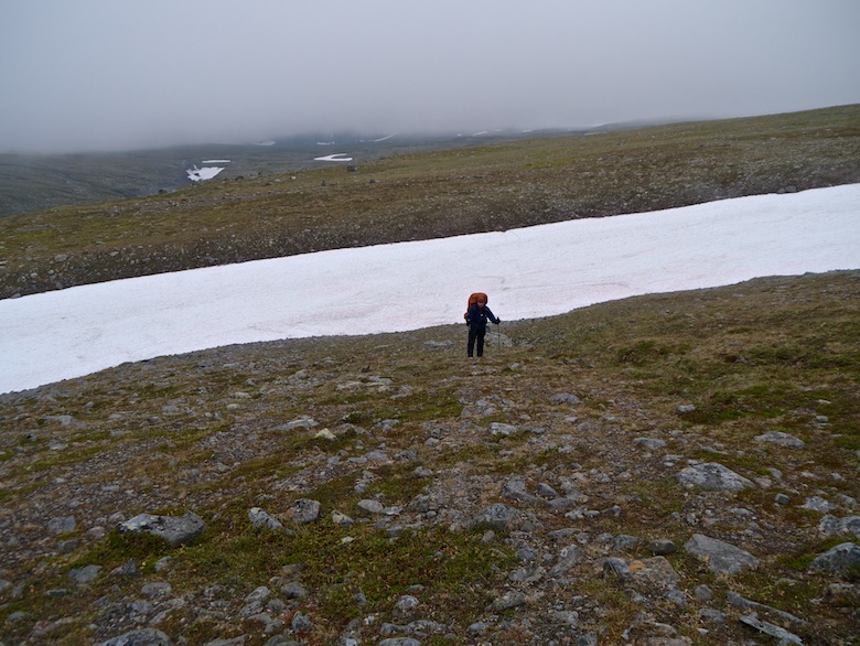
The problem with contouring slopes, especially in poor visibility is the fact that it feels like you are constantly walking up hill. It was with some relief to finally reach the high valley of Čoalbmevággi and its string of lakes. A sign pointed the way to the hut at Somashytta, 8 kilometres away. I knew that I would not make it that evening.

The wind whipping down the 750 metre high valley was ferocious, and when I found a spot that was relatively sheltered I decided to call it a day and pitch. Once changed into dry clothes and warm and snug in the tent I lay there and reflected on the day. My arm was throbbing and kept me awake as it was difficult to get comfortable. I lay there listening to the wind and unrelenting rain.

Something did not feel right at dawn. I sat up to find that the foot end of the tent was submerged in water, a small stream running through the porch. The bottom half of my sleeping bag and Thermarest were soaked, whilst my pack was positively floating. I immediately packed everything away, making sure that dry items remained dry and set off by 7am.

The wind had dropped slightly but the air remained as wet and misty as the day before. Water was running everywhere, the hills white streaks of water. As I crested a rise and looked down at what was meant to be a stream, my stomach knotted at what I was faced with. Flowing water filled a small valley, the faint trail entering the water and exiting it a couple hundred metres away. My boots were already saturated so I plunged straight in and slowly made my way across. Thankfully although the river was wide it only came to just above the knee and I made it to the other side without incident.

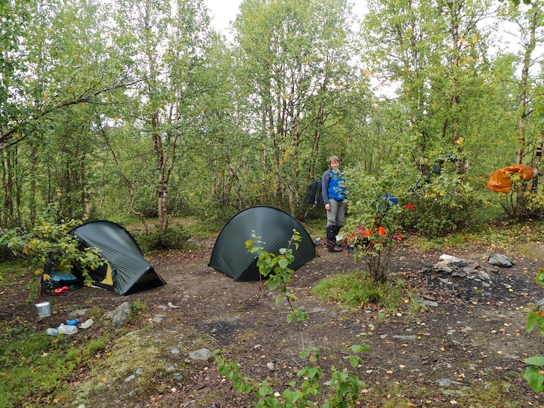
I was relieved to see the cabin eventually loom through the mist. There was a single occupant, a German chap called Thomas who had arrived the previous evening after a thirty kilometre battle through the weather. He had decided to take a rest day and although only 10am I decided that I also would not be continuing any further that day. Both myself and my kit was sodden and as I peeled off layers they were hung above the stove. The cabin was small with only two bunks sleeping four, plus space for a couple of people under the eaves. I bagged a bunk and soon had even more wet kit hanging from every available space. As I was finishing early for the day I placed my Spot3 device next to an open window in the sleeping area, firing off a couple of OK messages for my wife. The green flashing lights indicated that both went through ok, but more about that on the next and final trip report.

Not long after settling down with a hot drink and some food, three bedraggled Austrians appeared. It turned out that they were part of the group of five that had passed my tent the previous morning. Somehow they had got separated from the other two and had managed to follow the wrong trail. The two other Austrians had managed to find the hut the night before but they had the only map! The first thing they did once changed into dry clothes was give me a beer and then keep on topping up my coffee with strong rum. These guys definitely were not part of the lightweight brigade as they pulled bags of potatoes, tins and fresh steaks from their packs.

The last person to arrive later that afternoon was a serious young German lad who was thru-hiking the Nordkalottleden. He was doing it lightweight and definitely knew his technical fabrics.

As someone who prefers his own space, the tiny hut was almost a bit much for me with all the bodies inside. With the stove roaring and wet gear everywhere it soon resembled a very smelly sauna. I was also the only native English speaker among five German speakers, so some of the conversations were a bit lost on me!

As dusk started to fall and we were all beginning to get ready for an early night, vehicle lights were spotted approaching from further down the valley. Eventually three large quad bikes pulled up and the occupants entered the hut. It was clear that they had come to spend the night and were not happy that all the beds had been taken. We offered them the floor and then things started to get a bit heated. They were Sami men who were working with the reindeer in the mountains. Half of the hut is locked for which they have the key, whilst the other hut is for anyone to use. They said that they had forgotten their key and expected us to leave and pitch our tents (it was still very wet and windy and was now dark). Thankfully one of the Austrians spoke good Norwegian and managed to calm things down after lots of slamming of doors etc. They eventually ‘miraculously’ found the key to the locked side and with lots of swearing settled down for the night, after getting out chainsaws to noisily cut wood. The whole experience was rather unsettling as the Sami men were very big tough looking guys. To work outside in such a challenging area you would need to be pretty hard and hardy.

After all the excitement I found it difficult to sleep. My arm was still causing lots of pain which seemed amplified as I lay in bed, making it impossible to get comfortable in the tiny bunk.

It was with relief when someones alarm went off at 5am. I was keen to escape the cabin and head back into the lonely mountains.

The paper map that I used on this segment is the red covered Norge-serien 10154 Reisadalen.

Whilst hiking I shared my route live on Social Hiking. That route can be found here and viewable on Google maps.

If you’re interested in following this route on an electronic topo map they are in order below. You can click to view them full size.

October 7, 2015

Mountains, Marshes and Mosquitoes – Arctic Sarek 2015 (part 6)

by backpackingbongos

Part one.

Part two.

Part three.

Part four.

Part five.


Day Six – 27th August

Day 6

It felt rather novel laying in the Hilleberg Enan listening to the sound of wind and rain. I felt warm and snug and it was an effort to remove myself from a warm down filled cocoon. We had pitched in an exposed spot the night before, the tents shrugging off the stiff breeze. We both emerged into a world transformed from the past five days. The blue skies had been replaced by sodden grey clouds sitting heavily on the surrounding peaks. Although much of the views were now hidden the change in weather gave more drama to the landscape.

P1090930

P1090936

P1090940

Rather than dropping down to the reindeer herders hut to pick up the path we simply climbed over a saddle behind a low rounded peak. On the horizon we could see the line of metal posts that we had followed on the route out. It gave us something to aim for whilst the clouds teased us with their presence, often reducing the view ahead.

P1090941

P1090945

I was glad that we had previously done this route in good weather as it would have been tough not knowing the terrain, the highest parts were totally clagged in. We remembered to leave the line of posts at the correct place, just after a large snow bank blocked our descent route. The rain had made it slick and icy and we detoured around a significant portion of it. The way ahead was indistinct, we lost the sketchy path, doing our best to aim for the same spot where we had crossed the river a few days before.

P1090947

We managed to arrive at the exact spot, getting over the now faster flowing water with no difficulties. The next test was to cross further trackless ground to find the snow bridge over the next much wilder river. I was pleased that we navigated well, finding it on the first attempt. Once again it was slippery, patches of ice hidden amongst the snow. From a distance the snow looked like it was covered with blood but I think that it must have been some sort of algae.

P1090950

P1090951

Once past the snow bridge we picked up the good path that took us all the way back to Parek. We passed a solo backpacker who was not too keen on stopping for a chat.

P1090952

After such an exposed walk it was good to see the Parek bog below us once again, although I was not that enthusiastic about having to walk it again the following day.

P1090954

We found a great little camping spot at the top of the tree line at around the 800 metre contour. Whilst pitching we were passed by a young German trio heading up into the mountains. With it being late afternoon and the weather closing in I’m not sure that they made a wise choice. Any camping spot up there would be exposed and the weather was forecast to get worse. We attempted to sit and cook outside but spots of rain saw us retiring early to our tents.

P1090956

It hammered it down all night and the wind blew in big gusts (according to Chrissie) but I managed to sleep through the worst of it.


Day seven – 28th August

Day 7

It was wet and windy the following morning, not the most ideal conditions in which to break camp. One of the nice things about the Enan tent is that it is easy to separate the inner from the outer and pack it away dry whilst undercover. Chrissie had to come to the rescue when a big gust of wind meant that I got my fly sheet tangled on the local vegetation. It was clear that it was going to be a damp sort of day.

As we descended through the forest the path was running with water, vegetation dripping on us we brushed past. There are numerous small streams unmarked on the map, most of which we had not even noticed a few days before. So much rain has fallen that even these meant wet feet when crossing, one proving tricky. My mind turned to the upcoming large river crossing between two lakes, it turned out that Chrissie was also thinking the same thing, although neither of us initially voiced this.

The first bit of fun came at a marshy section prior to the main river. On the way out this had been crossed by a wooden platform which was now detached and floating on a large flooded area. There was no way that we were able to get across. Luckily a detour around the edge of the marsh and a bash through some trees got us to the river itself.

It was huge! The wide and placid river we had crossed a few days before had burst its banks, the wooden triangles showing the way across now hidden. There was no way of knowing how deep it was without giving it a go. On the positive side it flows between two lakes so there was not much of a current, at the very worst we would have to swim!

Chrissie was very unhappy about the situation and was convinced we would both die. Although I was nervous about the whole thing I pretended that it was nothing to worry about. Hopefully that rubbed off. Anyway it’s not like we had much of an alternative!

A few minutes later we were stripped down to our underpants, wearing boots and waterproof tops and big rucksacks. With the rain pouring down we must have been a bit of a sight. The crossing took what felt like an eternity, the rocks being slippery and the cold water coming up to our waists most of the way across.

You have not lived until you have emerged from a freezing cold river, soaked from the waist down whilst heavy rain falls from a cloudy sky. Here are a couple of photos showing what we managed to cross. Can anyone tell which brand of trousers Chrissie is wearing in the photo below?

Trousers

20150828_105614

Rain fell for the rest of the morning as we crossed long sections of bog, thankfully protected by duckboards. The weather matched the mood of the landscape.

20150828_112824

20150828_114732

Our goal for the day was the campsite where we spent the first night of the trip. This would then leave us with only a few kilometres the following day, so that we did not have to rush for the early afternoon bus. This time we were the first to arrive and had the pick of the best spots, although that still meant pitching on bare earth, the best way to get a filthy tent. It was another evening where the weather drove us inside early, some of the showers proving to be particularly enthusiastic.

P1090960

It was around dusk when the ‘fun’ started. Our tents got invaded throughout the night by an army of Arctic Voles. They were brazen little things, waltzing into an open porch in plain view. I actually had to smack one to make it run away! The end result by morning was a pair of stressed backpackers with chewed tents. Luckily they did not feel the need to chew the flysheets, they were more interested in joining us in our inner tents. I ended up with one small hole in my inner whilst Chrissie ended up with two much larger holes. One must have joined her during the night as she found a chewed bag inside the tent at the opposite side to the holes they had made.


Day eight – 29th August

scan0032a (1)

We were both a little battle weary by the time we packed our soaking wet tents into soaking wet packs, put on soaking wet waterproofs and set off down the trail to Kvikkjokk. The few kilometres passed quickly and we were back at the STF hostel with a couple of hours to spare. We picked up the bag of clean clothes we had stored there and paid about £5 each to use the shower. After wearing the same clothes for eight days it was nice to have something clean to wear.

The lunch at the hostel was good, setting us up for the long bus journey to Murjek, followed by the train to Luleå.

I have to say that I am totally smitten with the north, three journeys to Swedish Lapland and I am already planning the fourth. Where to go next is the question? The possibilities are endless.

If the demand is high enough I might do a short gear shakedown post, what worked and what didn’t, that sort of thing. On the other hand I might not.

September 26, 2015

Mountains, Marshes and Mosquitoes – Arctic Sarek 2015 (part 5)

by backpackingbongos

Part one.

Part two.

Part three.

Part four.

Day five – 26th August

I was up and out of my tent by 7.00am. Chrissie was up before me, standing looking down at the river, her face full of worry. It was clear that she was not keen at attempting to cross the river and I was careful not to push her into doing something she was not comfortable with. I would be lying to say that I was not disappointed, being keen to see the two lakes further up the valley, nestled amongst mountains of sheer black rock. However we had come to Sarek as a pair and that means compromises. Continuing the planned route was out of the question (an extra person and a rope I reckon would have got us safely across). I therefore set about persuading Chrissie into doing an alternative high level route I had cobbled together the night before.

Day 5

I had traced a line through areas where the contours widened out, linking together several shelves amongst steeper ground. The scale of the map is 1:100k and lacking detail, conditions under foot being a bit of a lottery. I was hoping that none of the steeper slopes would be covered in snow. Chrissie was willing to step into the unknown with me and give this mountain alternative a try. The only other viable route was to return the way we had come, neither of us really fancied that. It was still early when we left our campsite.

P1090840

The initial climb was up slopes covered in dwarf willow, this was eventually replaced by grass as the hillside got steeper.

P1090842

P1090843

P1090845 (1)

P1090850

We eventually got a glimpse of the snout of the huge glacier which was responsible for spawning the river we could not cross.

P1090851

P1090853

The originally planned route involved crossing the Njoatsosvagge river and valley and climbing steep slopes to a lake high on a plateau. This lake Goabrekjavraj soon came into view and it was clear that it would have involved a bit of a slog to get up there.

P1090855

We were now on the far side of the mountain range that had originally dominated our view at the beginning of the trip. From the forest to the south they offer up their gentle side. From the north they are composed of fearsome pinnacles of rock and glaciers hanging at improbable angles from steep dark rock.

P1090863 (1)

P1090865

From our lofty position I gazed into a long high level valley that runs parallel with the upper reaches of the Njoatsosvagge. Late August and much of it was still covered with snow. I imagine that it gives a wild and lonely through route to the north, perhaps one to try on my next trip back to Sarek.

P1090871

It was satisfying to sit on a mountain top at over 1300 metres whilst north of the Arctic circle. For the first time on the trip it was cool enough to pull on some warm clothing and there was not a mosquito to be seen. The weather was beginning to turn as forecasted, cloud bubbling up and covering the highest peaks.

P1090872

I have to say that the scale and majesty of the place was almost overwhelming. With cloud building over the dark jagged peaks there was a sense of menace in the air that I have not felt in Sarek before. It was clear that we were now in serious mountain territory, miles from civilisation and help if anything went wrong. It was at least three to four days of walking to get to a road. A place to truly feel your own insignificance.

P1090877

P1090878

We would often find ourselves skirting large patches of snow, unsure of what was beneath them. Water was running everywhere and we were afraid of walking across a small hidden lake covered in soft snow.

Bagatjavrasj is a large body of water which was mostly free from snow and ice. It was difficult however to tell how far the snow bank on the western side extended into the lake. There were large sunken craters that indicated that much of it was not above dry land. We gave it a wide berth.

P1090884

As we got closer to the wall of mountains they took on a truly terrifying appearance. Climbing them would be well out of my league, at least without someone who really knew what they were doing. The pinnacle of rock above was mesmerising.

P1090886

The vegetation was scarce, the ground covered by boulders and gravel, the odd patch of moss and lichen eking out a living. However even in such a brutal place there is beauty, tiny little flowers were thriving wherever they could find shelter.

P1090898

The outflow from the lake was surprisingly wide but thankfully shallow, we got across with dry feet after a large amount of rock hopping.

P1090899

P1090901

We had probably the most spectacular lunch break of the whole trip. A rock bench next to the icy crystal clear waters as they rushed down the mountain. The sun was warm enough to remove boots and socks and dry them out a bit. I got my stove on and made noodles, a hot lunch always satisfying when out backpacking.

P1090905

Nothing can beat sitting in the sun eating a tasty lunch and looking at a view like this.

P1090907

We crossed another river and followed it downstream for a while. On slopes high above the far bank we spotted a group of backpackers make their way slowly across a snow field. They returned our waves and soon disappeared amongst the rocks of the endless plateau.

Glacial moraines towered above us, their slopes steep and loose. It took a bit of effort for our tired bodies to make the climb. Gaining height the plateau behind made us feel like specks of dust on the landscape. Gently rolling rocky hummocks as far as the eye can see. A vast desert reaching to further snow capped mountains. It was good knowing that there are small signs of life in the shape of tiny flowers in an otherwise alien land.

P1090916

P1090918

P1090920 (1)

P1090921

Our route took us along a wide rocky shelf, steep slopes above and below. We entered a large boulder field of unstable rocks, each one wobbling underfoot as we took a step. Progress was slow and tiring, a slip would mean both pain and disaster. I was glad that I had good old fashioned leather boots on my feet. I don’t think I could have made it across in trail shoes.

After what felt like hours we descended steeply and sighed with relief when we felt grass beneath our feet. We could relax for a couple of miles of relatively easy walking above a series of deeply incised spurs that jut out above the valley below.

P1090924

The cloud was sinking ever lower through what had become early evening. Every now and again we would be enveloped in mist and a few spots of rain began to fall. We pulled on our waterproofs for the first time in five days, not bad for Sarek which has a reputation of being wet.

I was not one hundred percent sure about the planned descent into the gorge of the Ruopsokjahka, the map was not giving much away. All I knew was that it would be steep. Some Jedi map reading meant that we managed to descend into the only section that did not have cliffs or near vertical walls of vegetation. The skies opened, heavy rain making everything slippery just at the wrong moment.

We got across the river and pulled ourself up through sopping wet Dwarf willow on the other side. At the first flat bit of ground we got the tents pitched. After more than twelve hours on the go we were wet and tired. Wind whipped over our exposed spot, ragged clouds drifting not that far above us. Summer in Sarek had ended.

P1090934 (1)

September 23, 2015

Mountains, Marshes and Mosquitoes – Arctic Sarek 2015 (part 4)

by backpackingbongos

Part one.

Part two.

Part three.

Day four – 25th August

scan0003a

Sadly there were no reindeer to be seen when I emerged from my tent under yet another clear blue sky. It was looking like it would be another hot and uncomfortable day, especially seeing that we would be descending into a deep valley to make battle with the legendary dwarf willow. I had brought clothing that I thought would be suitable for the Arctic, little did I realise that my Merino base layer would prove uncomfortably hot. To save weight I had taken one set of clothing for walking and another for wearing in the tent. We were both prepared for wind and rain and temperatures in single digits. I know that it sounds like I am complaining about sun and blue skies, however I am aware of just how incredibly lucky we were to see Sarek under such superb conditions.

Anyway who can complain about waking up somewhere like this?

P1090792

After packing the tents we crossed the upland bowl, climbing onto another wide ridge.

P1090797

The view that greeted us to the north-east was mind blowing. Below us was the wide basin of the Njoastsosvagge which we would be walking later that day. This curves round to two high lakes crowded by jagged glacier covered mountains. The view was so good that I thought that I should present it to you twice.

P1090799

P1090801

It was one of the most impressive places that I have ever backpacked, only being surpassed the following day when we got higher and closer to the big peaks.

P1090807

P1090803

Above us an enormous fin of rock rose sheer into the blue sky. It was difficult to pin point exactly which mountain it was on our map as most of it was hidden by the bulk of other mountains. It is on the right of the photograph below.

P1090804

Route finding during the end of the previous day and the start of this was simplified by the line of metal posts that ran parallel to the narrow path. We pondered their use, coming to the conclusion that they would have something to do with the Sami who work the land and farm reindeer here.

On the descent into the Njoastsosvagge the posts and path diverge, we had to keep a keen eye out for the path which would become indistinct amongst the vegetation. The scale of the Njoastsosvagge increased the lower we got, it truly is a wild place. Having experience of walking through valleys in Sarek I had a good idea what was coming.

P1090817

Close to the valley bottom the path comes close to a locked hut. It is marked Renvaktarstuga on the map, my powers of deduction coming to the conclusion that it is used by the local Sami in relation to reindeer. We had planned to pitch there the night before, the surrounding area having several possible camping spots.

I had read that the river Ruopsokjahka can be tricky to cross. Its water was thankfully low and I managed to get across dry shod and without removing my boots. Just prior to the crossing we passed three young giants, all sporting massive packs, long beards and wooden staffs that would make Gandalf envious.

After the river crossing we managed to pick up a well-worn path for a while, giving us a false sense of security. Before we knew it the way forward looked like this.

P1090821

The next few hours was a battle with head high dwarf willow and rucksack grabbing birch. It was all rather exhausting, compounded by the fact that dwarf willow likes to grow in really boggy areas. Whilst we were fighting the green leafed monsters the bogs were trying to remove our boots. The mosquitoes buzzed in our ears whilst the large horseflies attacked us with stealth.

P1090823

Thankfully there were open areas, an opportunity to make forward progress and take time to enjoy the surrounding mountains.

P1090826

P1090828

The first testing river crossing of the trip was where the Balgatjahka meets the Skajdasjjahke. The river comes from both lakes and glaciers on the mountain plateau above. This means that it has a blue milky hue due to the glacial sediment. It was running pretty swiftly but there were sections where the water was calmer. We linked arms and crossed together, both of us soon regretting not removing our trousers. It was deeper than it looked, the water coming to the bottom of my boxers. The water once again was very cold!

P1090829

On the far bank we put modesty aside and stripped to our underwear, trousers being draped over bushes to dry in the sun. We were glad of the good weather as it would have been a miserable experience if it had been cold and raining.

The sun worked its magic and we were soon on our way wearing dry trousers.

P1090831

P1090832

We heard the Luohttojahka long before we saw it, the rushing water being hidden by the surrounding dwarf willow. I think that all the colour drained from Chrissie’s cheeks when she finally saw it. A great volume of milky white water was rushing at speed through the narrow confines of the river bed. This was a full on glacier fed river, totally opaque, the bottom not visible. The heat of the previous few days had obviously made a dent in the large glacier above.

I dumped my pack, changed into my river crossing shoes and removed my trousers in preparation for a solo test crossing. I got about a third of the way across, the water at mid-thigh proving far too strong a current to progress any further. It was also impossible to gauge how much deeper it would become. The risk of being swept away was far too great so I made a hasty retreat.

I tried to cross at a couple more places downstream where the river was a little wider, but the current was still far too strong. Our path was effectively blocked that afternoon.

I was hopeful that if the night was cool enough the water levels might drop due to most of the water coming from a glacier above the 1300 metre contour. If we got up early enough we might just get across. The alternative was to walk back the way we had come but there was no way I wanted to battle the dwarf willow again.

There was one other possibility, but that would involve a long hard mountain day crossing giant boulder fields and traversing steep slopes below glaciers. I went to bed pouring over a rather inadequate 1:100k map.

P1090835

P1090838

Here’s a short video showing the river we could not cross along with that nights camp.

September 15, 2015

Mountains, Marshes and Mosquitoes – Arctic Sarek 2015 (part 3)

by backpackingbongos

Part one.

Part two.

Day 3 – 24th August

scan0033a

I woke in the middle of the night feeling hot, sweaty and trapped. I fought my way out of my sleeping bag, got the door open and spent a couple of minutes on my hands and knees being sick. I think that the heat of the previous day along with a couple of days travelling had taken its toll on my system. Luckily that was the only time during the trip that I was sick, so probably not a bug.

I felt much better when I emerged from the Enan at 7.00am into a bright warm morning. Chrissie was already up and about, sitting on a rock next to her tent, cup of tea in her hands. Despite the less than ideal ground conditions on which to pitch (lumpy, rocky, prickly vegetation) you can’t ask for a more idyllic location.

P1090715

P1090717 (1)

After stopping short the day before we were packed and away by 8.30am to walk the short distance to the first river crossing of the trip. I was aware of its sound during the night, the noise seemingly amplified as I lay in my tent.

Although wide it was a perfect introduction to river crossings for Chrissie who admitted that the prospect of some of the rivers made her nervous. She decided to keep her boots and gaiters on whilst I changed into the Inov-8 Recolite 180’s brought along specifically to cross rivers. This one is about a hundred metres from bank to bank, joining two lakes. This meant that the water was calm, especially after a week of hot and sunny weather. A series of wooden triangles built up on stones show the best way across. The water barely came to mid calf, although by the time I had crossed my feet were numb with the cold!

P1090721

As I was changing back into warm fluffy socks and dry boots Chrissie decided that in future she would remove her inner soles and save a pair of socks specifically for crossing rivers.

The good path continued on the other side, climbing up through a dense forest of birch, duckboards once again giving easy passage across the boggy stretches. We had hoped to see the huts at the Sami settlement of Parek but the path veered too far to the left and we decided not to do a detour.

Soon we were leaving the forest behind, the birch trees thinning out and the mountains rising above us. A handy boulder gave a good spot in which to sit and snack whilst swatting at the mosquitoes. We thought that they had disappeared whilst walking through the forest but they came back with a vengeance as soon as we stopped moving.

P1090726

Leaving the last of the trees behind there was a real feeling of entering a mountain landscape. The path which initially is very clear climbs across vast moorland slopes, the vegetation growing closer to the ground, even the dwarf willow being no more than knee height.

P1090727

Unfortunately with the heat the views to the south were very hazy. We still got a sense of the scale of the Parek bog that we had crossed, numerous lakes interspersed with forest and marsh.

P1090731

The higher we got the more intermittent the path, often disappearing amongst the boggier sections. Above 900 metres it changed direction to contour high above the Sahkokjahka river, heard but unseen deep in the valley below. We would have to cross it higher up, the German we met the day before warning us of its difficulty. ‘It’s a white water river’ he told us several times. The look on Chrissies face at the time suggested that she was not thrilled with that prospect.

P1090732

Further on a side stream was completely buried under snow, still solid despite the hot sun, the kicking of steps a change of rhythm.

P1090741

P1090743

We approached the Sahkokjahka at the point in which it was covered by a huge snow bridge. We could see water disappearing under it, the exit end fractured, car sized chunks of snow ready to break off. We crossed together, the exit steep and needing good steps kicking in to get to the solid ground above.

The high plateau we then crossed was very reminiscent of the Cairngorms. I looked back at the 2000 metre mountains behind us, picking out what looked like climbable routes to their summits. I could even make out the tiny red dot of the observation hut near one of the tops.

The next river crossing was wide and rocky but also shallow. I was pleased to find a way across without getting my feet wet.

P1090749

P1090751

Another long climb followed, the path disappearing underfoot but the occasional cairn marking the way. This section was boggy in parts and the mosquitoes and horseflies were still biting, even once we passed the 1000 metre contour.

P1090755

A large snow bank blocked the final slope of the day, unavoidable and increasingly slushy. We passed a young couple on their way back to Kvikkjokk, nearly out of food after being in Sarek for ten days. Tanned and fit looking they wished us luck as they headed down the way we had come.

P1090756

P1090758

Finally we arrived on the mountain plateau at 1200 metres, an absolutely breathtaking spot. My eyes were immediately drawn to the north-east, a wall of incredible mountains towering above the twin lakes at the head of Njoatsosvagge and our planned destination for the following day.

P1090761

P1090764

Our route dropped into a large upland bowl at the head of a stream. Once again we were short of our intended destination by a few kilometres and it was still early afternoon. However we could not face the long descent down into a valley and the heat and insect life that would bring. The ground next to the stream was soft and springy and there was a gentle breeze blowing. Pretty much perfect. We therefore did not waste much time in pitching the Enan’s.

P1090768

P1090769

Of course what happened as soon as we had pitched? The breeze dropped and the mosquitoes came out to play. The ones at 1200 metres seemed to be bigger and meaner than the ones we has encountered in the forests. I took myself off to sit on a rocky bluff overlooking the valley for a while, a breeze keeping them at bay. Returning to the tents for dinner it was back on with the windproof and head net in an attempt to keep my sanity. With the sun shining it was far too hot to retire to our tents. It was hard to believe that we were camped at 1200 metres above the Arctic Circle!

The evening was spent pacing round camp cursing the sun which still sets late at the end of August. Eventually it dipped and the temperature fell enough for us to escape to our tents. I lay on top of my sleeping bag gazing out through the mesh door watching the light change on the surrounding hills.

I must have nodded off because I woke to a clicking noise and some grunts close behind my tent. I popped my head out to see a herd of reindeer pass us within a few metres. A real National Geographic moment that I won’t forget. Just a shame that by the time I got my out camera they had moved off.

P1090778

By then the temperature had dropped, the sky blushed pink with the moon beginning to rise. A perfect end to a great day.

P1090782

P1090785

P1090786