


I sneaked out of Nottingham before dawn on the Good Friday, heading north fuelled on pain au chocolat and strong coffee. Surprisingly traffic was light and seven hours later the Real food Cafe in Tyndrum made me part with my cash for their fantastic fish and chips. With a happy stomach I did the best I could to keep my eyes on the road whilst passing Rannoch Moor and Glencoe. The Peaks were absolutely plastered in white, dazzling in the sun under a blue sky.
I timed the Corran ferry to perfection. I approached the slipway just as the last of the vehicles was loaded, getting on in the nick of time. Five minutes later I was the only vehicle that turned right on the single tracked road, the rest heading towards the fleshpots of Strontian. Although only on the other side of Loch Linnhie it felt a million miles from the bustling A82.
There is space for several vehicles to park at the entrance of the Cona Glen, although I was the only one. As I got out of the car the sun was beating down and with no breeze it could almost have been mistaken for summer. On this side of the Loch the hills around me appeared to be almost free of snow, although I could not see further up the glen. This gave me a bit of a dilemma. Would I need the ice axe and crampons that were in the boot or should I just take some microspikes instead?
In retrospect a bit of a daft debate to be having in a warm sheltered valley. In the end I just took my crampons. Now was that a wise decision?
Day 1 – 16 kilometres with 440 metres ascent

Once past a couple of buildings I had that wonderful feeling that you get when entering wild country. I knew that each step would take me further and further away from the hum drum of daily life. I passed and was re-passed a few times by an estate worker on a tractor feeding deer. Finally he rumbled off down the glen leaving me with the sound of silence. For the next four nights I would be alone, the only contact with the outside being if I could get reception on the summits to call my wife.
The lower part of the glen has some beautiful woodland around Doire Driseach, an area I had initially planned to camp. Even after driving for nine hours and it being past 4.00pm I decided to push on and see how far I could get before dark. It has to be said that there were many tempting places to pitch a tent within that first hour.


The track gave rapid progress and I was soon passing the Corrlarach bothy. Unfortunately it was locked and after pressing my nose against the windows I walked on. I was rather jealous of its location with some grand looking Scotts Pine nearby.


The air was absolutely still and I soon worked up a sweat, stripping down to just a base-layer. I was getting tired but decided I would camp right at the head of the glen no matter whether darkness overtook me.
Further up a strange conical mound rises above the river, from that point onwards the scenery would take on a wilder feel as the last of the trees were left behind.
The sun dipped below the mountains in front of me and immediately I had to pull my jacket back on. Looking east I noticed that Ben Nevis had taken on a pink glow, everything lower plunged into shadow. I retrieved my torch from my pack, ready for when my eyes finally needed battery operated assistance.

The solid landrover track was replaced by a much older and rougher version, ruts through the bog and heather. The illusion of being in the middle of nowhere was soon shattered when I came across several diggers, mounds of earth and a mashed up looking landscape. This part of the track was being upgraded, starting higher up and working its way down. I hope that nature takes its course and heals the wounds.
As darkness started to approach I noticed an unusual smell in the air. A sharpness that burnt my nostrils. With the air perfectly still and dry and with stars starting to appear overhead, I realised what it was. It was the smell of cold descending on the glen.
The final few minutes were undertaken by headtorch, I finally arrived at a large loop on the river where cropped grass provided a perfect spot to camp. As I was pitching frost bagan to form on the tent in front of my eyes. I measured -4C and it had only just got dark, it was going to be a cold night.
Day 2 – 10 kilometres with 850 metres ascent

It was a night of extraordinary coldness but also dryness. As one point I blew my nose to find within minutes the tissue had frozen solid. The river that I was pitched next to became silenced in the night as ice imprisoned its surface.
I woke to find the sun warming the tent and the sound of the river cracking and groaning as the ice started to recede. I was quickly up, a coffee in hand to take in the spot that I had arrived at in the dark. And what a spot it was!


The night before I had decided that I would not do the planned long glen route, but instead take it easy and try to summit a few hills. After breakfast I packed a few things in my sack and left the tent to relax in the sun.
The terrain was immediately steep and rough but I was quickly getting a measure of the scale of my surroundings, the river cutting a large loop across the head of the glen.

The main track to Callop was reached and I enjoyed a short distance without being pestered by contours. The track soon continued downwards and I started up the steep trackless slopes of the Corbett Sgorr Craobh a Chaorainn. With a lack of general fitness it was tough going, but I reminded myself that at least all my heavy gear was in the tent and not on my back. I was soon resting and enjoying the view down the Callop Glen and towards Streap.
Whilst at the same time eyeing up the steep and rough slopes that I still had to climb.

I always find that once a good amount of height has been climbed something switches in my mind and the going becomes easier. For some reason that usually comes at about the 600 metres contour. Maybe my legs and lungs sense that the ordeal will soon be over.

Arriving at a col below the main summit I got a good view of Sgurr Ghiubhsachain which I had planned to be my second Corbett of the day. The steepness of its slopes and the snow made me feel just a little bit nervous.

The actual summit of Sgorr Craobh a Chaorainn is guarded by a line of cliffs on the south western side, these looking rather formidable when I saw them for the first time. However I spotted a line through easier ground towards the south. The going was rather steep and loose but I soon found myself approaching the summit cairn.
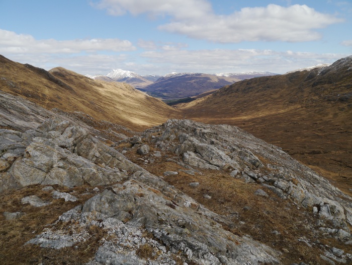
For such a low summit (or because of it) the panorama was simply breathtaking with the crystal clear air. Ben Nevis took centre stage but also on offer was the length of Glen Spean, the Glencoe hills and an array of peaks spreading towards Knoydart. However more than a match for any of the famous showstoppers was the rugged land closer to hand. I could not understand why the place was not crawling this bank holiday weekend with such good weather. They say that a picture is worth a thousand words, so I will let a few do the talking.


The descent was tricky whilst I searched for the line I had used on the ascent. It’s amazing how things appear so much steeper when going downhill. Once back below the cliffs it was an easy yomp downhill to the col followed by an ascent up grassy slopes. The rocky summit of Sgurr Ghiubhsachain began to look intimidating, the route mentioned in guidebooks appearing as a solid wall of snow-covered rock.

The map suggested that it could be possible to bypass the steep rocky section and sneak up to the summit through a breach in its southern defenses. A grassy contouring line below the crags gave a view down the entire length of Cona Glen.

The final half hour to the summit is one that I will file away in the memory bank with the label ‘Experiences learned’. The plan to sneak around the crags was going well until I came across a large wide gully filled with snow. This was south-facing so had turned into slippery mush. My crampons were rendered useless and instead an ice axe would have been the tool to use just in case I slipped whilst trying to get across. There was no way I was going to attempt a crossing without, as any slip would have meant a fast exit into the glen below.
I spotted a series of snow free grassy ledges above so started the process of linking them together. This turned out much harder than anticipated and there were a few worrying moments of climbing up ribs of rock that were steeper than I would have liked. My knees were knocking a bit by the time I reached the trig point. I should have simply stuck to the established route.
The view was good though!


I knew that fellow blogger Andy Jones from Surfnslide was in the adjacent glen doing a spot of Corbett bagging with a mate. There was talk of trying to meet up. Therefore I fired a text to see where they were camping, letting him know that I may turn up the following evening.
Thankfully the south-west ridge provided a much gentler descent, the view towards the Glenfinnan viaduct being one of mountain perfection. My original plan had been to continue over the subsidiary summit of Meall nan Creag Leac but I could not summon the energy. Instead I took a knee jarring descent straight down into the glen, which now looks seemingly impossible on the map. The Corbett Druim Tarsuinn which would hopefully be my objective the following day looked to be even more plastered in snow and down to a lower level.

Once again it was pretty much dark by the time I got inside my tent, the temperature already having plummeted to the wrong side of freezing.
Lesson learned so far on this trip: Never judge mountain conditions by peering up from a warm sunny valley!
