I have to admit that I was hard pushed to locate Great Asby on the map. Chrissie has been cherry picking the best bits from the Dales Highway and invited Reuben the mountain staffy and myself to join her for a weekend. The plan was to do a linear walk from Sedbergh across the Howgills and into little frequented limestone country to the north.
With modern technology there was no need to locate Great Asby on a road map. I punched its name into the sat nav and headed the car in the direction I was told. It turns out that it is a charming village and I parked up next to the church. Moments later Chrissie’s husband Geoff pulled up in their campervan and drove me south to Sedbergh to meet Chrissie and Dixie. The campervan turned into the cheapest tea van in Cumbria before I set off with Chrissie, Dixie and Reuben. Geoff would meet us in Great Asby the following afternoon.

Day 1 – 10.5 kilometres with 680 metres ascent
Howgill Lane took us out of the town and we were soon climbing the steep bridleway past Lockbank farm. The initial ascent was an absolute killer for me. Lack of fitness plus a recent worsening of my asthma meant that I was soon gasping for breath. Luckily the increasing views gave plenty of excuses to stop, the rooftops of Sedbergh glinting under shafts of sunlight.
As we contoured around the southern slopes of Winder the wind hit us. It was strong enough to make the taking of photos difficult without everything becoming a blur. The path soon levelled out a bit and we could see the route ahead to Arant Haw, occasionally being brushed by clouds.

A second lunch was grabbed just below the summit, the leeward slopes being surprisingly sheltered. A guy we had passed earlier had warned us about just how windy it was on the tops. It was good to have a rest before the promised battering.
The summit was quickly gained but we did not stop except to dig out gloves. The ridge narrows slightly at Rowantree Grains, giving great views down into Bram Rigg Beck. The clouds swirling above were highly atmospheric but unfortunately the higher hills ahead were stubbornly covered.


Climbing up towards Calders the wind increased dramatically as it was funnelled between a narrow col. I got out my wind measuring thingymajig which measured an average wind speed of 44 mph, the strongest gust being 49.7 mph. The climb was tiring and at one point the wind made me lose my balance and I found myself on the deck. Another effect of the wind was to have a horizontal trail of nose juice blowing across the fell side.
The trig point of the Calf was hidden in thick dank cloud, damp enough to warrant waterproof trousers. Once again we did not hang around and quickly set off along the bridleway that would take us down into Bowderdale.
There was a surreal moment when we saw a strange shape loom out of the mist, to me it looked like a misshapen cross. It turned out to be two backpackers huddled together consulting their map. They both jumped when Reuben appeared out of the murk at speed to say hello.
Thankfully the wind dropped a little as we descended into Bowderdale, however the cloud was sitting lower on the hills, the air full of drizzle. A wild and lonely looking valley in the conditions.

We followed the path down the valley for a while, eventually picking a flattish spot to camp next to the river. The wind was gusting again, being funnelled directly up the valley. I was pitching my new Kifaru Megatarp for the first time out in the wild and the wind did not make things easy. I eventually wrestled what felt like a hundred metres of fabric into position, pinned firmly down with a grand total of 21 pegs. It was not going anywhere.

Along with the Megatarp I had purchased the Tarp Annex which transforms the shelter from a tarp to a four season shelter. This has a stove boot sewn into it to take the small Kifaru woodburning stove.
It was not yet cold enough to bring along the woodburning stove. I also did not want to risk using it in strong winds, a lightweight chimney being blown about would just be asking for trouble.

The weather meant that we were soon in our individual shelters. It was dark by 6.30pm which felt really early after a summer of wild camping. Although stable the Megatarp was a bit noisy, there is a lot of fabric to catch the wind. The plus point was that I had plenty of room to spread out inside, the evening passed quickly with a good book.
Day 2 – 17 kilometres with 280 metres ascent
One of the main problems of sleeping in a floorless shelter is that my pillow seems to go walkabout in the night. At least in the confines of an inner tent there is nowhere for it to go. I kept waking to find that it had pinged off somewhere, the downside of a lightweight inflatable pillow.
The rain stopped soon after midnight but the wind continued to increase towards dawn, howling up the narrow valley. Chrissie came along to wake me around 8am and we had a leisurely couple of hours around camp before packing and setting off at 10am.

The last time I had walked down Bowderdale was with Martin Rye during a stormy January weekend a few years ago. Then Bowderdale beck was an absolute raging torrent, even the small side streams proving difficult to cross. We urgently headed down the valley half expecting to find our cars washed downstream.
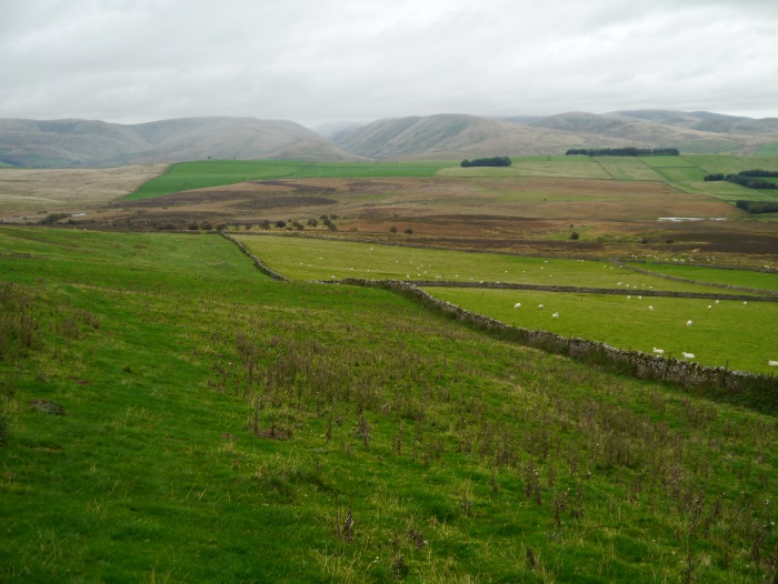
Although windy the conditions this time were much more benign and it was good to get an actual view of this long and remote valley.


A dry stone wall provided shelter for a snack break before we headed through the hamlet of Bowderdale and crossed the busy A685 via an underpass.
Access land is marked on the map next to the building at Rigg End, however it proved very difficult to actually access. A gate in its final years of life was tied to an equally ancient fence post by numerous ancient pieces of twine. It took a fair bit of patience to pick it all apart whilst Dixie decided she wanted a quick fight with Reuben.
Once through it was a pleasant plod through moorland following a track on the map which no longer exists on the ground. Perhaps everyone has been put off by that gate.

As we were descending towards a bridge we saw Geoff and Tilly in the distance. Tilly spotted us and came bounding over at great speed, the usual happy labrador. It turned out that Geoff had spent a while trying to find us on our route. However he had managed to become geographically challenged on the way, muttering something about how the map was wrong. When unsure of your location it is always best to blame the Ordnance Survey.
Lunch was taken before climbing onto a lovely area of limestone pavement. The views back were of the northern Howgills, their summits covered by a uniform blanket of cloud. Fingers crossed that the rain would hold off until we got back to our vehicles.
Tilly and Reuben behaved splendidly through an area of four-legged woollies, taking not a blind bit of notice of them. They were too busy larking around, Reuben’s terrier instincts meaning he won tug of war with a stick and stole Tillies ball.
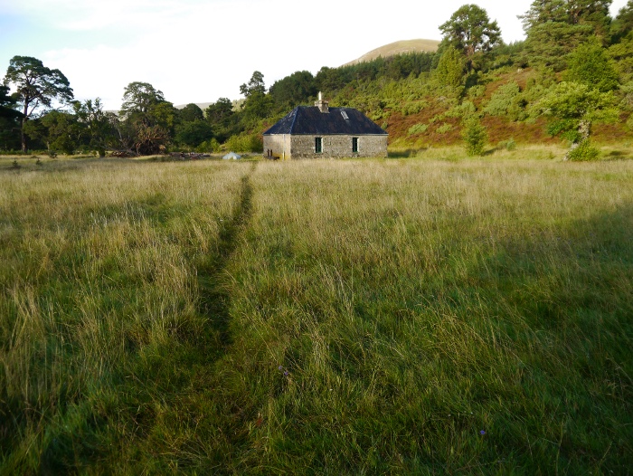
This wedge of limestone country between the Howgills and the Eden valley is worthy of exploration if you are looking for a bit of peace and quiet. It would be lovely on a warm summers day with sky larks singing overhead.

The final section of the route took us down through cattle infested territory. Most were fine until the final field where one started to take offence at the dogs, the field being full of surprisingly young calves. We all got over the stile in time and no harm was done.
The skies opened a few minutes before reaching the village where the best tea van in Cumbria was waiting for us. Coffee and homemade apple pudding set me up for the long drive home.
You can read Chrissie’s version of the trip here.