


One of the things that I had been pondering during the night was whether the track marked on the 1:50,000 map existed on the ground. A quick scout around the area the night before showed a worrying lack of anything track like, this being confirmed by the 1:25,000 map. Two maps by Ordnance Survey failing to confer was a bit worrying as my onward route was through a dense forestry plantation.
The damp weather followed by a cold still night meant that the Enan was a bit drippy with condensation when I got up. I was soon packed and making my way across wet tussocky ground, the grasses having a fine autumnal tint.

Of course the track did not exist, instead I followed the stream to the forest edge and was pleased to see that there was a small strip of unplanted ground on either side of it. Mist was rising through the trees and there was not a breath of wind. The silence was deafening as I slowly made my way into this long forgotten corner.

The going was tough, the ground uneven and the grass long and wet. Encroaching trees had me crossing the stream several times, wire from a long rotten fence attempting to trip me. One area was a large quaking bog, the grassy surface wobbling like jelly. I had to close my eyes as I pushed through the dense conifers to avoid it, wary of an errant branch poking me in the eye.
It was with relief when I finally reached the security of a forestry track, a rotten observation post giving me something to lean against and have a well-earned snack. The track then led down to the glen of the Ettrick Water.
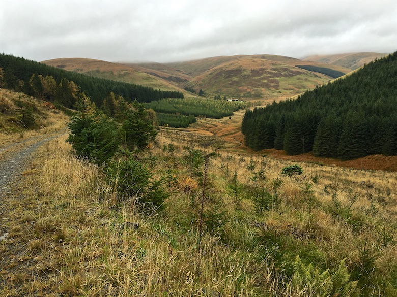
I had planned on climbing some of the hills on the other side of the glen but the cloud hung low and I lacked the enthusiasm to do so. Instead I followed the forestry track on the south side, this being rudely interrupted by a steep, rocky and highly vegetated ravine. I had wondered why the map showed a break in the track for a couple hundred metres, now I knew why. I gingerly climbed down to the stream and then hauled myself up the far side, using vegetation as hand holds, feet scrabbling for purchase on wet rock. The track on the other side had long since grassed over, providing a pleasant if rather slippery alternative to the usual gravel.
As the trees thinned the view down to the head of the Ettrick Water and towards Over Phawhope bothy was one of utter devastation. Extensive felling was taking place and huge new tracks and bridges had been installed since the last time I had visited. The area was a right old mess, although the bothy itself looked as good as ever.


I had toyed with staying and having a lazy afternoon in front of the fire. However it no longer occupied what previously had felt like a wild out of the way spot. The logging trucks trundling up the other side of the glen did not add to the ambience!
Instead I took to one of the new tracks, leaving it to climb directly up the hillside where there was a break in the forest. This was initially tough going due to the tussocky ground but it got easier with height.

A detour to bag White Shank and then a wonderful rolling route to the summit of Capel Fell. The views across Moffat Dale to the higher cloud covered hills was spectacular.

The weather continued to be changeable, a dry-stone wall providing scant shelter from the wind.


It would have been possible to march back down to the car and get home that night. However despite the weather I was keen to spend another night wild camping. A descent due east led to Ettrick head and a welcoming sign amongst old lichen encrusted fence posts.


A short descent along the Southern Upland Way and there was a hint of drama with the steep sloped hills.

I had planned on an exposed pitch with a view but the gusty wind made me settle on a sheltered spot close to the footbridge over the Selcoth Burn. Sadly this meant that the view from my tent was reduced to the grassy bank in front. However as the wind continued to blow and the rain started to fall I was glad to be tucked away for the night.

There is an alternative high level alternative on the Southern Upland way that zig zags its way up Cat Shoulder and onto Croft Head. This avoids the monotony of the forestry plantations below. I came this way many years ago when the zig zags had just been put in, they were a great eyesore then. They are still not very pretty but I certainly appreciated the assistance they provided in getting me up the steep slopes. With the ravine of the Selcoth Burn as a backdrop I did not need many excuses to stop and get my breath back.


The wind was fierce along the top of Crookedside Sclenders, ragged banks of cloud being blown up from the damp forest below. The route was marked by wooden posts, although these disappeared at just the wrong moment when descending from Gateshaw Rig, it’s a shame that the route is not marked on the OS maps.
Before joining the main forestry track the path went through an area of golden grasses, lit up by the autumn sun. The path twisted and turned, there was fun to be had in trying to work out where it went next. It is obvious that not many people come this way. I had been out for four days and not seen another hiker in the hills during that time.

